
Wherever practicable, provision shall be made for suitable open space for parks, playgrounds and recreational areas In commercial areas provision shall be made for suitable open space for walkways (connecting parking facilities with commercial structures), malls, sitting areas, etc Due consideration shall be given to the preservation of natural features, including large trees, groves, waterways, scenic vistas, historic grounds and structures and other community assets�
A. Reserve strips, controlling access to streets, alleys, subdivisions or adjacent areas are prohibited�
B. Rights-of-way and/or easements for sanitary utilities, road construction or maintenance or for drainage purposes, public utilities or for any specific purpose shall be required by the Township Supervisors as needed, the location and width in each case to be as determined by the Supervisors�
(1) Building setback lines shall be measured from the nearest side of the right-of-way or easement to the proposed building�
(2) Nothing shall be permitted to be placed, planted, set or put within the area of an easement The area shall be kept as lawn�
(3) The owner of any lot, upon written request by the township and at the owner's sole expense, shall remove anything placed, planted, set or put (with or without knowledge of this regulation) within the area of any easement�
(4) To the fullest extent possible easements shall be adjacent to rear or side lot lines�
C. No right-of-way nor easement for any purpose whatsoever shall be recited or described in any deed unless the same has been shown on the approved plan Any error found in a deed shall be immediately corrected and rerecorded in the Office of the Recorder of Deeds for Montgomery County at Norristown, Pennsylvania, at the sole expense of the subdivider�
D. Easements�
(1) Utility Easements with a minimum width of twenty (20) feet shall be provided for common utilities and drainage when provided in unwanted dedicated land Nothing shall be permitted to be placed, planted, set or put within the area of an easement, but shall be maintained as lawn�
�
(2) Drainage Drainage easements shall be required along natural watercourses to a minimum width of twenty-five (25) feet from the center line and may be used for storm and sanitary sewers and as open space Where conditions warrant, such as in floodplains, additional width shall be required in such cases where runoff treatment requires a wider easement Runoff studies must prove such requirements beyond the delineated floodplain�
(3) Dedication Where stormwater or surface water will be gathered within the subdivision or land development and discharged or drained in volume over lands within or beyond the boundaries of the subdivision or land development, the subdivider, developer or builder shall reserve or obtain easements over all lands affected The easements shall be adequate for such discharge of drainage and for carrying off of such water and for the maintenance, repair and reconstruction of the same, including the right of passage over by vehicles, machinery and other equipment for such purposes, and shall be of sufficient width for such passage and work The subdivider, developer or builder shall convey, at no cost, the easements to the township upon demand�
A. Monuments shall be of stone or concrete and located on the right-of-way lines at corners, angle points, beginning�
- and end of curves and as otherwise-required Monuments shall be indicated on all plans They shall be placed after�
a new street has been completed The center line of all new streets shall be marked with spikes and referenced to permanent monuments or structures A certified copy of thus reference information shall be given to the Township Engineer Permanent reference monuments of case concrete or durable stone twenty by four by four (20 x 4 x 4) inches, with beveled edges, shall be set by the subdivider, developer or builder at all corners and angle points of the boundaries of the original tract to be subdivided and at all street intersections and intermediate points as may be required�
B. Bench marks The township elevations are based on the Township Sanitary Sewer System Datum and/or the United States Geodetic Survey Map Location and elevation is available to all engineers and surveyors upon request to the Township Engineer's office All contours and elevations shown on plans must be based on this system�
G. Staking requirements All lots shall be staked by the registered engineer or surveyor for the subdivider when final grading has been completed This stakeout shall be visible and completed before an owner or occupant moves into the property All lot corner markers shall be permanently located and shall be at least five-eighths inch metal pin with a minimum length of twenty-four (24) inches, located in the ground to existing grade�
[Amended 8-16-1995 by Ord. No. 141; 4-17-1996 by Ord. No. 1471�
A. General requirements�
(1) Storm drainage required A storm sewer system and all appurtenances shall be required to be constructed by the owner or subdivider in any area from which the surface or subsurface drainage could impair public safety or cause physical damage to adjacent lands or public property The system shall be designed to collect water at any point where four (4) cubic feet per second or greater is accumulated at the bottom of all vertical grades and immediately upgrade from all street intersections The system shall discharge to the nearest practical natural drainage channel or storm system Where the nearest practical natural drainage channel or storm system is beyond the boundaries of the property being developed, the developer shall either provide the township with copies of appropriate stormwater easements over any land between the property being developed and the nearest practical natural drainage channel or storm system (such easements to be satisfactory in form in the opinion of the Township Solicitor), or return any stormwater which has been collected in a detention basin or other stormwater facility to a sheet flow condition before leaving the property being developed in such a manner as will not result in erosion or flooding of adjoining properties and in such a design as shall be approved by the Township Engineer�
(2) Off site improvements Any increase in runoff may require necessary corrective measures, including deeds of easement, deemed appropriate by the Board of Supervisors to alleviate any off site drainage problem affected by the subdivision or land development The costs for such measures will be borne entirely by the developer or subdivider�
(3) Total watershed evaluation The future use of undeveloped areas upstream, as shown on the approved Township Comprehensive Plan, shall be taken into account in the design of all storm sewer systems The capacity and maximum anticipated present flow of the capacity and maximum anticipated present flow of the body or system receiving the proposed systems) discharge shall be calculated to verify its capability of receiving any additional flow caused by the development or subdivision The runoff from any proposed development shall be subject to an evaluation which includes the anticipated runoff from other existing or proposed developments within the same watershed Stormwater management facilities designed to serve more than one (1) property of development in the same watershed are encouraged Consultation with the township is required prior to the design of such facilities�
(4) Underdrains All building foundations, grade slabs and cellar floors located in soils that have a community development limitation degree of moderate to severe seasonal high-water table, as defined by on-site soils test witnessed by the Township Engineer, shall be provided with an underdrain system This system shall provide for drainage of the enclosed volume above the slab and relief of subsurface water to a depth of no less than six (6) inches below the slab or foundation bottom The system shall consist of a perforated pipe field of the herringbone or gridiron configuration in coarse, gravel-filled trenches that are in direct contact with the slab or foundation subbase The excavation shall provide a minimum of five one-hundredths (0 05) foot/foot slope to the gravel-filled trenches�
(5) Prohibition Against Non-Stormwater Discharges.�
(a) Prohibited Discharges.�
[1] No person in the Municipality shall allow, or cause to allow, stormwater discharges into the Municipality's separate storm sewer system which are not composed entirely of stormwater, except (1) as provided in Subsection [2] below, and (2) discharges allowed under a state or federal permit.�
[2] Discharges which may be allowed, based on a finding by the Municipality that the discharge(s) do no significantly contribute to pollution to surface waters of the Commonwealth, are as follows:�
�
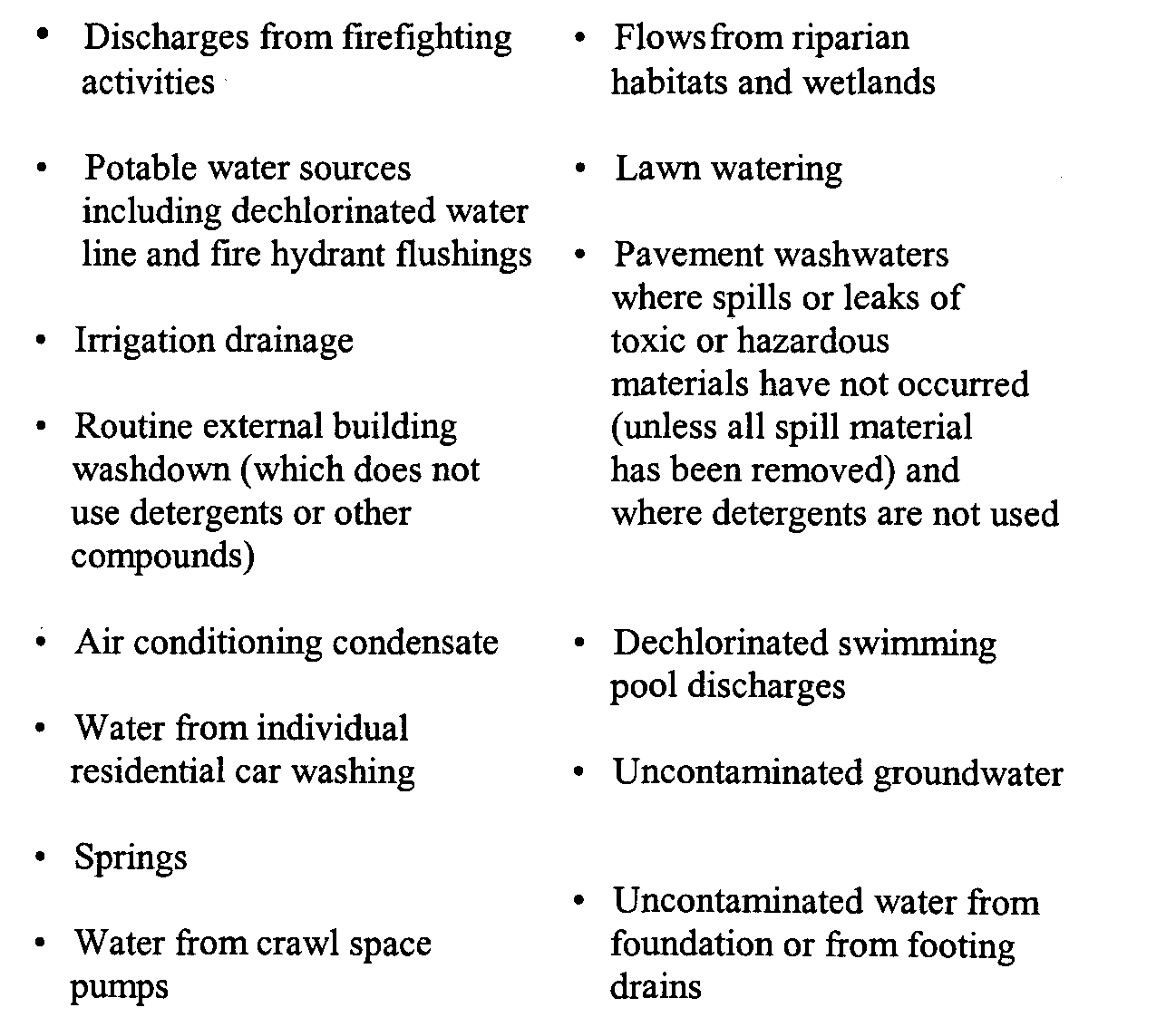
[3] In the event that the Municipality determines that any of the discharges identified in Subsection [2] significantly contribute to pollution of waters of the Commonwealth, or is so notified by The Pennsylvania Department of Environmental Protection (DEP), the Municipality will notify the responsible person to cease the discharge.�
[4] Upon notice provided by the Municipality under Subsection [3], the discharger will have a reasonable time, as determined by the Municipality, to cease the discharge consistent with the degree of pollution caused by the discharge. �
[5] Nothing in this Section shall affect a discharger's responsibilities under state law.�
(b) Prohibited Connections. The following connections are prohibited, except as provided in Section [2] above:�
[1] Any drain or conveyance, whether on the surface or subsurface, which allows any non-stormwater discharge, including sewage, process wastewater, and washwater, to enter the separate storm sewer system, and any connections to the storm drain system from indoor drains and sinks; and �
[2] Any drain or conveyance connected from a commercial or industrial land use to the separate storm sewer system which has not been documented in plans, maps, or equivalent records, and approved by the Municipality.�
**Webmasters Note: The previous subsection, A(5), has been amended as per Ordinance No. 2004-197.�
(6) Responsibility of developer Any developer or property owner is advised that (notwithstanding approved plans) they are ultimately responsible for a stormwater system which ultimately meets the requirements of the Pennsylvania Stormwater Act' and does not cause erosion or flooding on adjoining properties Notwithstanding approval by the Township Engineer or Board of Supervisors, if field conditions prove an approved plan to be unworkable or ineffective, the necessary corrections will still be the responsibility of the developer or property owner�
(7) Best Management Practices. All Stormwater Management Plans shall incorporate Best Management Practices (hereinafter, "BMPs") to comply with Federal and State stormwater management regulations. BMPs shall be defined as follows:�
(a) Best Management Practices (BMPs). Schedules of activities, prohibitions of practices, structural controls (e.g., infiltration trenches), design criteria (e.g., vegetated buffers), maintenance procedures, and other management practices to prevent or reduce pollution to the waters of the Commonwealth. BMPs include Erosion and Sedimentation Control Plans, Stormwater Management Act Plans and other treatment requirements, operating procedures and practices to control runoff, spillage or leaks, sludge or waste disposal, drainage from raw material storage, and methods to reduce pollutant loadings, to recharge groundwater, to enhance stream base flow and to reduce the threat of flooding and stream bank erosion.�
**Webmasters Note: The previous subsection, (7), has been added as per Ordinance No. 2004- 197.�
B. Stormwater management plan�
(1) General requirements For all subdivisions and land development proposals, a stormwater management plan and report shall be submitted containing, but not limited to, the following�
(a) A suitable map of the total watershed (a United States Geological Survey Quadrangle Map is sufficient) with pre-development and post- development areas outlined�
(b) Suitable maps and drawings showing all existing and proposed drainage facilities affecting the subject property�
(c) A plan of the proposed stormwater drainage system attributable to the subdivision or land development�
(d) The design computations for the stormwater drainage systems, including-storm-drain. pipes and inlets, runoff control measures and culverts and drainage channels�
(e) A plan of the grading of the subject subdivision or land development�
(f) A plan of the erosion and sedimentation procedures to be utilized�
(2) Stormwater drainage plan A complete plan of the stormwater drainage system, showing all pipes, swales, channels, structures and detention basins, shall be submitted as part of the stormwater management plan The drainage areas into each inlet or structure must be delineated on the plan of the storm drainage system�
(3) Storm drain pipes and inlets All pipe and inlets shall meet material capacity and construction specifications as outlined in the latest revisions of the PennDOT Form 408 and the PennDOT Design Manual�
(a) Design flow rate The storm dram system shall be designed to carry a fifty-year peak flow rate The design fifty-year peak flow rate into each inlet shall be indicated on the stormwater drainage plan The fifty-year flow rate shall be determined by the rational formula as follows�
�
Q=CIA�
Where�
Q.= Peak runoff rate in cubic feet per second (cfs)�
�
C. = Runoff coefficient equal to the ratio of the peak runoff rate to the average rate of rainfall over a time period equal to the time of concentration�
I. = Average rainfall intensity in inches per hour for a time equal to the time of concentration�
A.= Drainage area in acres�
NOTE Appropriate values of the runoff coefficient and rainfall intensity can be found in the Commonwealth of Pennsylvania Department of Transportation Design Manual, Part 2, Highway Design, Chapter 12�
(b) Overflow system An overflow system shall be provided to carry flow to the detention basin when the capacity of the storm-drain pipe system is exceeded The overflow system shall be of sufficient capacity to carry the difference between the one-hundred-year and the fifty-year peak flow rates�
(c) Inlet capacity�
[1] All inlets must be designed to accommodate the fifty-year peak flow rate The capacity of all C- , M- or S-type inlets shall be determined from the Commonwealth of Pennsylvania Department of Transportation Design Manual, Part 2, Highway Design�
[2] The design capacity of all four-foot special inlets shall be five and five-tenths (5 5) cubic feet per second, and for all six-foot special inlets, the design capacity shall be six and five-tenths (6 5) cubic feet per second The capacity of each inlet shall be indicated on the stormwater drainage plan�
(d) Straight pipe sections Wherever possible, all storm-drain pipes shall be designed to follow straight- courses No angular deflections of storm sewer pipe sections in excess of five degrees (5) shall be permitted No vertical curves shall be permitted in the storm-drain pipe system�
(e) Minimum grade and size�
[1] All storm-drain pipes shall be designed to maintain a minimum grade of one-half of one percent (1/2 of 1%). All storm pipes shall have a minimum inside diameter of fifteen (15) inches or a cross-sectional area of one hundred seventy-six (176) square inches, except that pipes under a fill of twenty-five (25) feet or greater shall not be less than twenty-four (24) inches or have a cross-sectional area of less than four hundred fifty-three (453) square inches�
�
[2] Reinforced concrete pipe shall be used in all public rights-of-way and when the pipe is subject to vehicular or excessive overburden loading conditions, with corrugated metal pipe permitted only within field or lawn areas as approved by the Township Engineer�
(f) Pipe capacity The capacity of all pipe culverts shall, as a minimum, provide the required carrying capacity as determined by the following sources�
[1] United States Department of Commerce, Bureau of Public Roads, Hydraulic Engineering Circular No 5, Hydraulic Charts for the Section of Highway Culverts�
[2] United States Department of Commerce, Bureau of Public Roads, Hydraulic Engineering Circular No 10, Capacity Charts for the Hydraulic Design of Highway Culverts�
(g) Pipe arches Where headroom is restricted, equivalent pipe arches may be used in lieu of circular pipe�
(h) Allowable headwater depth At all inlets or manholes, the maximum allowable headwater depth shall be one (1) foot below the top of the inlet grate or the manhole cover�
(i) Horizontal pipe deflections A manhole or inlet shall be provided at all horizontal deflections in the storm pipe system exceeding five degrees (5)�
(j) Minimum and maximum cover A minimum of three (3) feet of cover shall be maintained over all storm-drain pipes The top of storm-dram pipes shall be at least one-half (1/2) foot below subgrade elevation The maximum cover over storm-drain pipes shall be ten (10) feet unless special structural design calculations are submitted or approved�
(k) Match crowns The crowns of all pipes tying into an inlet or manhole shall be set at equal elevations�
(l) Diversion of runoff All storm-dram pipes shall be designed to carry the runoff into a detention basin or similar facility utilized to control the rate of runoff.�
(4) Runoff control measures�
(a) Runoff control. The rate of stormwater runoff from any proposed subdivision or land development shall not exceed the rate of runoff prior to development. Where, in the judgment of the Township Engineer, the quantity of stormwater runoff will cause detrimental downstream impact, quantity will be a consideration in the method of stormwater regulations This standard shall be maintained for all storms, i.e., both high-frequency and low-frequency. In addition to Runoff Control, all Stormwater Management Plans shall also incorporate BMPs in conjunction with the permitting, implementation, and operation and maintenance of the selected stormwater runoff controls.�
**Webmasters Note: The previous subsection has been amended as per Ordinance No. 2004- 197.�
(b) Regional runoff control facilities The use of regional runoff control facilities which will combine and eliminate numerous smaller facilities is encouraged Consultation with the township is required prior to design of a regional runoff control facility�
(c) Groundwater recharge In general, all runoff control measures shall be designed to encourage groundwater recharge and shall be permitted only if suitable subsurface conditions are present The on-site recharge of all stormwater runoff shall be required if the Board of Supervisors determines that conditions so warrant�
(d) Runoff control devices The increased runoff which may result from subdivisions or land developments shall be controlled by permanent runoff control measures that will provide the required runoff control specified above All runoff control devices will be evaluated for the effectiveness to maintain the above-mentioned standard for all storms with a return period of up to one hundred (100) years In order to preserve community character, improve the environment and/or improve safety, the rate of runoff from subdivisions and land developments shall be controlled by one (1) or more of the runoff control devices listed below Any runoff control devices chosen for a specific site shall be appropriate for that site and shall be approved by the Township Board of Supervisors�
[1] Underground seepage beds, provided that such facilities meet the requirements outlined in § 130-24B(4)(e) for seepage beds.�
[2] Detention basins, provided that the maximum slope of earthen detention basin embankments shall be five to one (5 1) and provided that the basin meets the requirements outlined in § 130-24B(4)(f)�
[3] Wet ponds and other facilities designed to retain water year round, provided that such facilities will contain water year round and provided that the facility meets the requirements outlined in § 130-24B(4)(g)�
[4] Stormwater wetland basins, provided that such facilities meet the requirements outlined in § 130-24B(4)(h)�
[5] Naturalized detention basins, provided that such facilities meet the requirements outlined in § 130-24B(4)(i)�
[6] Additional alternative runoff control measures and BMPs may be considered by the Township in conjunction with Stormwater Management Plans. The Township and Township Engineer shall review all proposed alternatives, and shall determine specific design criteria, construction specifications, and operation and maintenance needs as required.�
**Webmasters Note: The previous subsection has been added as per Ordinance No. 2004-197.�
(e) Design standards for seepage beds�
[1] Storage volume shall be computed below the lowest elevation of the inflow pipe�
[2] Seepage beds shall be designed to empty the total design storm value in twenty-four (24) hours or less�
[3] Design consideration should not include infiltration rates in computing storage volume or a seepage bed However, the infiltration rate shall be used to meet the requirements that the seepage bed and/or pit shall empty in twenty-four (24) hours or less�
[4] The seepage bed shall have a minimum of twelve (12) inches of-cover and be located at least ten (10) feet from a basement wall and downhill from a building in the direction of surface runoff�
[5] Compaction of the seepage bed subgrade shall not reduce the soil infiltration rate�
[6] All seepage beds shall contain sediment traps accessible for maintenance, as required by the Township Engineer�
[7] An overflow system shall be provided for a storm exceeding the volume of storage and safe discharge at a noneroding velocity, converting a concentrated flow into a sheet flow�
[8] A high-permeability filter fabric shall surround the stone seepage bed to prevent migration of soil fines into the bed�
[9] Soil permeability tests (percolation tests) shall be made to a depth of not less than five (5) feet below the bottom of the seepage bed�
[10] Both horizontal and vertical seepage pits constructed of perforated pipes may be used Perforations shall be not less than five-sixteenths (5/16) inch in diameter and provide an opening area not less than three and thirty-one hundredths (3 31) square inches per square foot of pipe surface Provision shall be made for maintenance of each seepage pit�
[11] Infiltration seepage beds may be combined with stormwater management basins�
(f) Design standards for detention basins with maximum slopes of five to one (51) on embankments�
[1] Design of detention basins All detention basins shall be designed as per procedures developed by the United States Department of Agriculture, Soil Conservation Service, as outlined in its Technical Release No 55, Urban Hydrology for Small Watersheds�
[2] Basin Design Criteria The following design criteria shall be used .in the design of all detention basins in the township The basins shall be designed to detain the quantity of water resulting from a one hundred-year, twenty-four-hour storm (see the Soil Conservation Service Technical Release No 55), under full development conditions released at a maximum outflow rate equal to that resulting from a ten year, twenty-four-hour storm under present conditions All flows in excess of the above-mentioned standard shall flow over an emergency spillway The Board of Supervisors, upon consultation with the Township Engineer, may choose to relax this criteria on the individual project basis if it is conclusively demonstrated by the applicant that a relaxed criteria will provide a more beneficial overall stormwater management technique�
However, in no case will the criteria be relaxed beyond allowing the quantity resulting from a one-hundred-year, twenty-four-hour storm under full development conditions to be released at a maximum outflow rate equal to that resulting from a one-hundred-year, twenty-four-hour storm under present conditions�
[3] Perforated riser A perforated riser shall be provided at the outlet of all detention basins The riser shall be constructed of metal or concrete The riser shall extend to an elevation two (2) feet below the crest elevation of the emergency spillway The perforated riser shall be designed so that the rate of outflow is controlled by the pipe barrel through the basin berm when the depth of water within the basin exceeds the height of the riser Circular perforations with a maximum diameter of one (1) inch shall be spaced-eight (8) inches vertically and twelve (12) inches horizontally The perforations shall be cleanly cut and shall not be susceptible to enlargement All metal risers shall be suitably coated to prevent corrosion A trash rack or similar appurtenance shall be provided to prevent debris from entering the riser All risers shall have a concrete base attached with a watertight connection The base shall be of sufficient weight to prevent flotation of the riser An ants-vortex device, consisting of a thin vertical plate normal to the basin berm, shall be provided on the top of the riser A suitable perforated riser design is outlined in the Erosion and Sediment Control Handbook, Montgomery County Soil and Conservation Service, United States Department of Agricultures�
[4] Maximum depth of detention basins In general, the maximum depth of water in a detention basin shall not exceed five (5) feet�
[5] Emergency spillway Whenever possible, the emergency spillway for detention basins shall be constructed on undisturbed ground Emergency spillways shall be constructed of reinforced concrete, vegetated earth, concrete rubble or other approved material All emergency spillways shall be constructed so that the detention basin berm is protected against erosion The minimum capacity of all emergency spillways shall be such that the combined capacity of the emergency spillway and the principal pipe barrel equal the peak flow rate from the one hundred-year design storm The dimensions of the emergency spillway can be determined from the Montgomery County Erosion and Sediment Control Handbook Emergency spillways shall extend along the upstream and downstream berm embankment slopes The upstream edge of the emergency spillway shall be a minimum of three (3) feet below the spillway crest elevation The downstream slope of the spillway shall, as a minimum, extend to the top of the berm embankment The emergency spillway shall not discharge over earthen fill and/or easily erodible material�
[6] Anti-seep collars Anti-seep collars shall be installed around the principal pipe barrel within the normal saturation zone of the detention basin berms The anti-seep collars and their connections to the pipe barrel shall be watertight The anti-seep collars shall extend a minimum of two (2) feet beyond the outside of the principal pipe barrel The maximum spacing between collars shall be fourteen (14) times the minimum projection of the collar, measured perpendicular to the pipe The use of an O-ring pipe is required for all detention discharge pipes�
[7] Freeboard. Freeboard is the difference between the design flow elevations in the emergency spillway and the top of the settled detention basin embankment The minimum freeboard shall be two (2) feet�
�
[8] Slope of detention basin embankment The maximum slope of earthen detention basin embankments shall be five to one (5-1) The top or toe of any slope shall be located a minimum of five (5) feet from any property line Whenever possible, the side slopes and basin shape shall be amenable to the natural topography Straight side slopes and rectangular basins shall be avoided whenever possible�
[9] Width of berm The minimum top width of detention basin berms shall be ten (10) feet�
[10] Slope of basin bottom In order to ensure proper drainage of the detention basin, a minimum grade of two percent (2%) shall be maintained for all sheet flow A minimum grade of five-tenths percent (0 5%) shall be maintained for all channel flow�
[11] Low flow channel Low flow channels shall be constructed on the basin floor extending from all inflow structures to the outflow structure The low flow channel shall be constructed of a minimum of four (4) inches of concrete The center of the low flow channel shall be lower than the outside edges by six (6) inches, thus creating a swale to carry the flow to the outflow structure, causing little or no erosion of the basin floor A footer on both sides of the channel shall be placed to a minimum depth of six (6) inches�
[12] Energy dissipaters Energy dissipating devices (riprap, end sill, etc ) shall be placed at all basin outlets�
[13] The distance from the highest free water surface of any detention basin or drainage facility to a dwelling unit shall be a minimum of one hundred (100) feet�
(g) Design standards for wet ponds and other facilities designed to retain water year round�
[1] Wet ponds and other facilities shall meet all design standards outlined in § 130-24B(4)(f) for detention basins, except that embankments shall have a maximum slope of three to one (3 1)�
[2] The minimum permanent pool level shall be maintained to allow sufficient depth throughout the year to reduce the growth of unwanted vegetation and mosquitoes�
[3] The pond must be of sufficient size to allow the appropriate aquatic community needed to maintain a healthy pond ecology�
[4] An outlet structure shall be designed to allow complete drainage of the pond for maintenance purposes�
[5] Design of a detention facility with a permanent pool shall include the determination of the proposed site's ability to support a viable permanent pool The design should account for such factors as the required rate and quality of dry weather inflow, the quality of stormwater inflow, seasonal and longer-term variations in groundwater table and effects of expected pollutant loadings The Pennsylvania Fish Commission and Soil Conservation Service should be consulted during the design of these facilities�
(h) Design standards for stormwater wetland basins�
[1] Stormwater wetland basins shall meet all design standards outlined in § 130-24B(4)(f) for detention basins, except that embankments shall have a maximum slope of three to one (3 1)�
[2] Wetland areas within stormwater wetland basins shall be designed in accordance with the Handbook of Constructed Wetlands, Volumes 1 and 5, United States Department of Agriculture, 1995�
(i) Design standards for naturalized detention basins�
[1] Naturalized detention basins shall meet all design standards outlined in § 130-24B(4)(f) for detention basins, except that embankments shall have a maximum slope of three to one (3 1)�
[2] The detention basin shall be very free-form and curvilinear in shape so that from most edges of the basin, the whole basin will not be in view When the natural topography lends itself to straight-sided detention basins, the basin shall contain an island or peninsula planted with trees which is large enough and appropriately placed to reduce the perceived size of the detention basin Such basins shall have a perimeter length that is greater than or equal to the length derived by the following formula, where "x" equals the area of the basin in square feet�

As an alternative, naturalized detention basins may be created by constructing berms or using gabions to dam up stormwater in a natural depression or valley, provided that the topography and natural vegetation in the remainder of the basin is left in its natural condition�
[3] Naturalized planting materials, such as wild flowers and nonaggressive meadow grasses, which tolerate wet, intermittently wet and usually dry areas of the basin, shall be planted throughout the basin Trees and shrubs may be planted in the basin where they will not interfere with the function of the basin�
Design information As part of the stormwater management plan and report, all design information shall be submitted, including but not limited to the following�
[1] A general description of proposed facilities and the operation of the runoff control measures�
[2] All computations of the stormwater runoff before, during and after construction, including all supporting material�
]3] When applicable, a sketch of the berm embankment and outlet structure, indicating the embankment top elevation, embankment side slopes, top width of embankment, emergency spillway elevation, perforated riser dimensions and spacing of anti-seep collars�
[4] When applicable, design computations for the pipe barrel and perforated riser�
[5] A plot of the stage/storage (acre/feet versus elevation) and all supporting computations�
[6] Flood routing computations�
[7] When applicable, a detailed plan of the trash rack and ants-vortex device�
[8] A plan, at a scale of one (1) inch equals fifty (50) feet, showing the grading and landscaping around the detention basin�
(5) Culverts and drainage channels�
(a) Design flow standard All culverts and drainage channels shall be designed to carry a flow rate equal to a fifty-year, twenty-four-hour storm (Soil Conservation Service, Technical Release No 55)�
(b) Erosion prevention All drainage channels shall be designed to prevent the erosion of the bed and bank areas The flow velocity in all vegetated drainage channels shall not exceed the maximum permissible velocity to prevent erosion Suitable bank stabilization shall be provided where required to prevent erosion of the drainage channels Where storm sewers discharge into existing drainage channels at an angle greater than thirty degrees (30) from parallel to the downstream channel flow, the far-side bank shall be stabilized by the use of riprap or masonry and/or concrete walls The stabilization shall be designed to prevent erosion and frost heave under and behind the stabilizing media�
(c) Maximum side slope Any vegetated drainage channel requiring mowing of the vegetation shall have a maximum grade of three (3) horizontal to one (1) vertical on those areas to be mowed.�
(d) Design standard Because of the critical nature of vegetated drainage channels, they shall, as a minimum, conform to the design procedures outlined in the Montgomery County Erosion and Sediment Control Handbook Several acceptable sources outline procedures for nonvegetated drainage channels, including the following�
[1] Bureau of Public Roads, Hydraulic Engineering Circular No 5, Hydraulic Charts for the Selection of Highway Culverts�
[2] Federal Highway Administration, Hydraulic Engineering Circular No 13, Hydraulic Design of Improved Inlets for Culverts�
(6) Detention basin landscaping�
(a) Topsoil A minimum of six (6) inches of topsoil material shall be placed on all areas affected by the basin construction (bottom of basin, side slopes, top of berm, etc) The material must meet the requirements of the Pennsylvania Department of Transportation Form 408 Specifications, as amended�
(b) Drainage channels and retention areas All storm drainage channels and retention areas, whether existing or proposed, shall be graded and planted to effectively naturalize area(s) so as to become an integral and harmonious part of the landscape by contour and type of plant material employed�
(c) Basin landscaping All basins shall be planted and landscaped in accordance with § 130-28G(7) of the Worcester Township Subdivision and Land Development Ordinance, as amended by Ordinance No 131 on May 19, 1993, by the Township Board of Supervisors�
(7) Post-Construction Stormwater Runoff Controls for New Development and Redevelopment, Including Operations and Maintenance of Stormwater BMPs.�
(a) A "Regulated Earth Disturbance Activity" shall be defined as an earth disturbance activity of one acre or more with a point source discharge to surface waters or the Municipality's storm sewer system, or five acres or more regardless of the planned runoff. This includes earth disturbance on any portion of , part, or during any state of, a larger common plan of development. This only includes road maintenance activities involving twenty-five acres or more of earth disturbance.�
(b) No Regulated Earth Disturbance Activities within the Municipality shall commence until approval by the Municipality of a plan which demonstrates compliance with State Water Quality Requirements after construction is complete.�
(c) The BMPs must be designed to protect and maintain existing uses (e.g., drinking water use; cold water fishery use) and maintain the level of water quality necessary to protect those uses in all streams, and to protect and maintain water quality in "Special Protection" streams, as required by statewide regulations at 25 Pa. Code Chapter 93 (collectively referred to herein as "State Water Quality Requirements").�
(d) To control post-construction stormwater impacts from Regulated Earth Disturbance Activities, State Water Quality Requirements can be met by BMPs, including site design, which provide for replication of pre-construction stormwater infiltration and runoff conditions, so that post-construction stormwater discharges do not degrade the physical, chemical or biological characteristics of the receiving waters. As described in the DEP Comprehensive Stormwater Management Policy (#392 0300 002, September 28, 2002), this may be achieved by the following:�
[1] Infiltration: replication of pre-construction stormwater infiltration conditions; �
[2] Treatment: use of water quality treatment BMPs to ensure filtering out of chemical and physical pollutants from the stormwater runoff; and �
[3] Streambank and Streambed Protection: management of volume and rate of post-construction stormwater discharges to prevent physical degradation of receiving waters (e.g., from scouring and erosion).�
(e) DEP has regulations that require municipalities to ensure design, implementation and maintenance of BMPs that control runoff from new development and redevelopment after Regulated Earth Disturbance Activities are complete. These requirements include the need to implement post-construction stormwater BMPs with assurance of long-term operations and maintenance of those BMPs.�
(f) Evidence of any necessary permit(s) for Regulated Earth Disturbance Activities from the appropriate DEP regional office or County Conservation District must be provided to the Municipality. The issuance of an NPDES Construction Permit (or permit coverage under the statewide General Permit (PAG2)) satisfies the requirements of Subsection (a).�
**Webmasters Note: The previous subsection, (7), has been added as per Ordinance No. 2004- 197.�
C. Disclaimer Nothing in this section shall be construed to affect any suit or proceeding pending in any court or any rights acquired or liabilities incurred or any permit issued or any cause or causes of actions existing under the ordinances of the Township of Worcester prior to enactment of this section�
D. Severability The provisions of this section are severable, and if any section,- sentence, clause, part or provision thereof shall be held illegal, invalid or unconstitutional by any court of competent jurisdiction, such decision of the court shall not affect or impair the remaining sections, sentences, clauses, parts or provisions of this section It is hereby declared to be the intent of the Board that this section would have been adopted as if such a legal, invalid or unconstitutional section, sentence, clause, part or provision had not been included herein�
E. Failure to enforce not a waiver The failure of the township to enforce any provision of this section shall not constitute a waiver by the township of its right to future enforcement hereunder�
F. Ratification Any township ordinances which are not replaced, changed or affected by implication by the language of this section are hereby ratified and confirmed�
G. Effective date This section shall take effect and be enforced from and after its approval as required by law�
H. Stormwater Violation Sanctions.�
(1) Public Nuisance.�
(a) The violation of any provision of this Stormwater Management Ordinance is hereby deemed a Public Nuisance.�
(b) Each day that a violation continues shall constitute a separate violation.�
(2) Enforcement.�
�
(a) In the event of a violation of this Stormwater Management Ordinance, the Municipality may order compliance by written notice to the responsible party. Such notice may require without limitation:�
[1] The performance of monitoring, analyses, and reporting; �
[2] The elimination of prohibited discharges; �
[3] Cessation of any violating discharges, practices, or operations; �
[4] The abatement or remediation of stormwater pollution or contamination hazards and the restoration of any affected property; �
[5] Payment of a fine to cover administrative and remediation costs; �
[6] The implementation of stormwater BMPS; and �
[7] Operation and maintenance of stormwater BMPS.�
(b) Failure to comply within the time specified shall also subject such person to the penalty provisions of this Stormwater Management Ordinance. All such penalties shall be deemed cumulative and shall not prevent the Municipality from pursuing any and all other remedies available in law or equity.�
(3) Suspension and Revocation of Permits and Approvals.�
Any building, land development or other permit or approval for Regulated Earth Disturbance Activities issued by the Municipality may be suspended or revoked by the governing body for any of the following:�
(a) Noncompliance with or failure to implement any provision of the permit;�
(b) A violation of any provision of this Stormwater Management Ordinance; or�
(c) The creation of any condition or the commission of any act during construction or development which constitutes or creates a hazard, nuisance, pollution or which endangers the life or property of others.�
�
(4) Penalties.�
(a) Any person, firm or corporation who or which shall violate or fail, neglect, or refuse to comply with any of the provisions of this Stormwater Management Ordinance shall, upon conviction thereof, be sentenced as provided in Chapter 1, Article II, General Penalty. Each day's violation shall constitute a separate offense and notice to the offender shall not be necessary in order to constitute an offense.�
(b) In addition, the Municipality may institute injunctive, mandamus or any other appropriate action or proceeding at law or in equity for the enforcement of this Ordinance. Any court of competent jurisdiction shall have the right to issue restraining orders, temporary or permanent injunctions, mandamus or other appropriate forms of remedy or relief.�
**Webmasters Note: The previous subsection, H., has been added as per Ordinance No. 2004- 197.�

