A. Bridges and culverts shall be designed to meet the current Pennsylvania Department of Transportation standards to support expected loads and to carry expected flows They shall be constructed to the full width of the right-of-way�
B. Approval of the Water and Power Resources Board, or its successor, of the commonwealth is required when the area drained upstream of the point under consideration exceeds an area of 1/2 square mile.�
A. Sewers Wherever practicable sanitary sewers shall be installed and connected to the township sanitary sewer system In areas not presently served by public sanitary sewers, the township may require, according to Act No 537 passed by the General Assembly of Pennsylvania (1965),2 in addition to installation of temporary individual on-site sewage disposal facilities, the installation and capping of sanitary sewer mains and house connections, if studies by the Township Supervisors indicate that extension of public sanitary sewer trunks of laterals to serve the property subdivided appears probable or necessary to protect public health�
(1) When a feasibility analysis conducted by the Township Engineer, Local Enforcer and District Sanitarian has ascertained that sanitary sewers are practicable, then sanitary sewers, with connection to each building in a subdivision or land development, shall be installed at the expense of the applicant or subdivider and connected to the township sanitary sewer system�
(2) If outfall sewers are not available in the vicinity but are considered reasonably necessary in the near future by the township or the Pennsylvania Department of Environmental Protection for the area in question, a system of sewers, together with all necessary laterals, extending from mains to the street right-of-way line shall be installed at the expense of the subdivider or applicant The sewer lines shall be suitably capped at the limits of the subdivision or land development and the laterals shall be capped at the right-of-way line The sewer installation shall conclude the construction within rights-of-way or easements to bring the sewer to the future connection with the township sanitary sewer system�
(3) If sanitary sewers are not to be installed at the tune of subdivision and development, subdividers shall grant, reserve and set aside easements in streets and roads for installation and maintenance of sewer lines at such time that the subdivision or land development shall be a part of the township sanitary sewer system�
(4) A sewer shall be considered to be planned for extension to a given area any time after preliminary engineering and related studies have been completed and the construction of facilities adequate to serve the area containing the subdivision has been programmed for completion within a reasonable tune�
(5) When capped sewers are provided, on-site disposal facilities shall also be provided.�
(6) Size and grade Sanitary sewers shall have a minimum inside diameter of eight inches and a minimum grade of V2 of 1% and shall be laid on undisturbed earth or thoroughly compacted clay fill and not on rock or crushed stone.�
(7) Manholes Manholes shall be located at intervals of 250 feet and at each change of line or grade. In exceptional cases the interval may be extended to not more than 300 feet Manhole appurtenances shall conform to current township standards�
(8) Laterals Lateral connections to each lot shown on the final plan shall be installed to the right-of-way line of the street prior to paving Each building shall have a separate connection to the township sanitary sewer system�
(9) This subsection shall be applicable to all subdivisions and land developments, whether utilizing public or private streets, and in the case of a subdivision or land development utilizing private streets, the subdivider or the applicant shall execute a recordable covenant with the township and/or township authority that, for the purposes of sewer connections, assessments and rentals, the rights and liabilities of himself and his grantees, heirs, successors and assigns shall be the same as if his property abutted a public street�
B. On-lot disposal system If public sewage disposal is not available and the sewage treatment is on a project or individual lot basis, such private facilities must be installed by the subdivider, developer or builder under the direct supervision of the state or local health officer or sewage enforcement officer for Act 537.$�
(1) Necessary tests and inspection Such officer shall require percolation tests, soil samples and other data to determine the size and extent of facilities�
- needed During installation of such- facilities,--and before final coverage, the state or local health officer and his officers shall make inspections and checks to assure that all requirements and specifications have been met They shall be granted free access to the development area at all times during this period�
(2) Certificate of approval After assuring that all requirements and specifications have been met, the appropriate Board will then issue a certificate of approval to the Secretary of the township as a requirement to final plan approval�
(a) The type of on-site sewage disposal system to be installed shall be determined on the basis of location, topography, available area, soil characteristics, permeability and ground water elevation The disposal area to be provided shall be determined by the results of percolation tests, soil classification and depth of water table and such other tests as may be deemed necessary. Proof of the adequacy of such facilities shall be furnished by a registered professional engineer or other person qualified to the satisfaction of the Township Supervisors The reports of such tests shall be required at each disposal area One percolation test per lot shall be required when the subdivider is dividing ground into lots and is not building immediately�
(b) All percolation tests shall conform to the standards of the Commonwealth of Pennsylvania�
(c) The "usable area for sewage disposal shall be shown on the preliminary plan for each lot The "usable area" shall be situated beyond the radius of the water supply well and shall conform to all rules and regulations or future amendments thereto of the Pennsylvania Department of Environmental Protection and the Township of Worcester No portion of an on-site sewage disposal system may be located within a required front yard or within 30 feet of any property line No waver will be granted from thus prohibition unless it is demonstrated to the satisfaction of the Supervisors that no other location for such system is possible [Amended 4-1?-1996 by Ord. No. 1461�
(d) Proximity to wells In no instance shall a septic tank, tile field or other effluent disseminating system be located uphill from a drilled well and shall not be closer to it than 100 feet nor 10 feet to any dwelling or property line�
A. All water and gas mains and other underground facilities shall be installed prior to street paving at locations approved by the township for the full width of the right-of-way�
B. Underground utilities�
(1) All gas and water mama shall be installed underground All electric, telephone and communication services, both main and service lines, shall be provided by underground cables, installed in accordance with the prevailing standards and practices of the utility or other companies providing such services, except where it is demonstrated to the satisfaction of the Township Supervisors that underground installations herein required are not feasible because of physical conditions of the lands involved or other valid reasons All main underground cables which are within the right-of-way of a street shall be located as specified by the Township Supervisors�
(2) In order to promote and facilitate the undergrounding of utility distribution lines, a letter of endorsement shall be required from the suppliers of utility service (not limited to electrical, telephone or cable television) of the developer's choice wherein the applicant acknowledges that underground utilities are feasible and shall be consummated as part of the improvement plan A statement relative to the intent of the developer to provide underground utility service shall be placed on the final plan requisite to final approval of such plan�
�
(3) The provisions in this chapter shall not be construed as to limit or interfere with the construction, installation, operation and maintenance of public utility structures or facilities which may hereafter be located within public easements or rights-of-way designated for such purposes�
(4) Light standards are to be placed as required by ordinance Power sources for such standards shall be placed underground as required�
(5) Along arterial roads and major highways all new electrical service should be placed underground�
�
[Amended 5-19-1993 by Ord. No. 131; 9-17-1997 by Ord. No. 153; 8-19-1998 by Ord. No. 166; 12-15-1999 by Ord. No. 177]�
A. Intent.�
(1) The intent of this section is to provide landscaping requirements applicable to all land development in order to promote groundwater recharge, to stimulate air purification and oxygen regeneration, to provide for noise abatement, to retard erosion and sedimentation and to otherwise maintain the township's natural amenities�
(2) Article I, Section 27, of the Constitution of the Commonwealth of Pennsylvania states that people have a right to clean air, pure water and to the preservation of the natural, scenic, historic and aesthetic values of the environment It is the intent of these landscape requirements to protect this right by conserving existing vegetation and/or requiring new plant material in critical areas of land developments Further, it is the intent of these landscape requirements to protect the health, safety and welfare of Worcester by promoting sound landscape design standards and practices which take into account the horticultural requirements of individual plant species, aesthetic characteristics and safety considerations of landscaping plans Specifically, it is the intent of these landscape requirements to preserve existing healthy plant communities such as woodlands and to require new landscape plantings in critical areas of new developments in order to�
(a) Reduce soil erosion by minimizing stripping of existing woodlands or tree masses hereby preserving existing soil and protecting Worcester's-water quality�
(b) Reduce stormwater runoff velocity and quantity by preserving and providing planting areas where runoff velocities are reduced and stormwater can infiltrate, ultimately recharging local groundwater supplies�
(c) Improve air quality by conserving existing or creating new plantings that produce oxygen and remove carbon dioxide from the atmosphere�
(d) Provide habitat for wildlife such as small mammals and birds. (e) Provide windbreaks, shade and other microclimate benefits of trees and landscape plantings�
(f) Conserve historically, culturally or environmentally important landscapes such as wooded hillsides, scenic views or aesthetic natural areas�
(g) Preserve and enhance property values of Worcester through the implementation of good landscape architectural standards�
(h) Provide planted buffers between land developments that act to visually' integrate developed areas into the existing landscape�
W.Preserve or provide planted and architectural visual screens around visually obtrusive site elements within areas to be developed�
Enhance the aesthetic appearance of the community and provide privacy and beauty�
(k) Conserve energy through moderating solar radiation (shade)�
B. Application This section shall apply to the following types of subdivision and land developments�
(1) Single-family detached dwelling uses of more than one building lot�
(2) Multifamily residential uses�
(3) Agricultural and residential-agricultural uses authorized by special exception or conditional use�
(4) Shopping center and commercial uses�
(5) Limited industrial uses�
(6) Mobile home development and other residential alternative uses�
C. The provisions of this section are not intended to restrict existing residential owners from removing trees from their property nor to restrict the clearing of land for agricultural purposes�
D. Definitions As used in this section, the following terms shall have the meanings indicated�
BUFFER - An area designed and functioning to separate the elements and uses of land(s) which abut it and to ease the transition between them.�
CALIPER - The diameter of a planting tree as measured at a point on the trunk six inches above the ground surface�
CANOPY TREE - In general, those whose mature heights may exceed 50 feet In natural woodlands, such trees make up the uppermost layer of the forest�
DBH - The diameter of a tree at breast height, measured 4 112 feet from the ground surface.�
�
DRIPLINE - A generally circular line, the circumference of which is determined by the outer reaches of a tree's branching points�
ENCROACHMENT - Any physical action which may jeopardize the health and longevity of a natural feature as that term. is described in Subsection F(1).�
GROUNDWATER RECHARGE - Replenishment of geologic structures and rock and soil interstices which have the capacity to store water�
HEDGEROW - A line or band of plants 100 feet or greater in length where seeds collect and are left undisturbed, such as along fence lines or property lines or between fields, or that is specially planted, i.e., to act as a windbreak�
SPECIMEN TREE - A plant worthy of preservation because- of -species, size; shape, form, historical importance or any other significant characteristic, including canopy trees over 20 inches DBH and understory trees greater than six inches DBH�
UNDERSTORY TREE - Trees whose mature heights are generally less than 50 feet In natural woodlands, understory trees occur below the upper layer canopy trees�
WOODLAND - A stand of woody vegetation covering at least one acre, predominantly trees of varying age or size and including at least 50% cover of trees at least six inches DBH�
�
E. Landscape plan submission requirements�
(1) Tree survey plan�
(a) The township shall require the developer or subdivider to verify the presence of existing trees on a site by field investigation or by the use of aerial photographs A separate tree survey plan at a scale of not less than one inch to 50 feet shall be submitted showing the location of existing live trees with a DBH of six inches or more, except in large wooded areas which are not proposed to be disturbed The edges of large wooded areas to be preserved shall be clearly delineated on the initial tree survey plan and all revisions�
(b) The tree survey plan shall include the following�
[1] Plan scale, date, North arrow, property lines and location map with zoning district designations for the site and adjacent properties�
�
[2] Existing contours at two-foot intervals.�
[3] Individual freestanding trees with trunk diameters of six inches DBH or greater, indicating the location and diameter of each tree.�
[4] All trees meeting the definition of specimen tree shall be identified as such on the plant and shall be subject to the alternatives analysis as described in Subsection F(4)�
[5] Trees in hedgerows or lines with trunk diameters of six inches DBH or greater, indicating the outer canopy or drip line of the tree grouping�
[6] Trees in woodlands or groves with trunk diameters of six inches DBH or greater, indicating the outer canopy or drip line of the tree grouping�
[7] Designation of existing trees to remain and existing trees to be removed, either by indicating individual trunk diameters with an "x" for removal or by cross hatching or similar graphical method to indicate woodlands to be removed Existing trees that are relocated on site shall be classified as existing trees to remain�
(c) When one or more existing trees six inches DBH or greater are proposed to be removed by a plan of development, they shall be replaced as described in Subsection F(7)(a) and (b)�
(d) The plan shall contain a schedule; listing trees over six inches DBH and the quantity of existing trees to be removed A schedule of the replacement trees indicating species, height, spread, caliper and quantity shall also be included on the tree survey plan or the final landscape plan.�
(e) The tree survey plan and/or any of the above requirements may be waived by the township if it is found that the application will involve a deminimis impact on landscaping (f) On plans with wooded tracts greater than 5 contiguous acres proposed to be disturbed, an applicant may consider a sampling approach as an alternative to single tree counting of all live trees greater than six inches DBH However, the sampling methodology must be submitted to the Worcester Township Shade Tree Commission for approval prior to its application�
(2) Preliminary landscape plan The preliminary landscape plan shall be drawn at a scale of not less than one inch to 54 feet and shall contain the following�
(a) Plan scale, date, North arrow, property lines and location map with zoning district designations for the site and adjacent properties�
(b) The location of all existing and proposed buildings�
(c) The location of all existing and proposed roads, parking, service areas and other paved roads�
(d) The location of all outside storage and trash receptacle areas�
(e) Sidewalks, berms, fences, walls, freestanding signs and site lighting.�
(f) The location, common names, quantity and sizes of all proposed trees, shrubs and areas for lawns or other ground cover (see Subsection H, Recommended plant materials)�
(g) A plant schedule indicating the botanical and common names, height, spread, caliper, quantity and any special remarks for all plant material proposed�
(h) If not provided on the tree survey plan, an enumeration of existing trees to remain, existing trees to be removed, existing and proposed water bodies and significant natural features�
(i) Existing and proposed contours at two-foot intervals, and, in order to determine the relationship of planting and grading, areas with slopes in excess of 10% shall be indicated on the plan�
(j) Information in the form of notes or specifications concerning planting and areas to be devoted to lawns Such information shall convey the proposals for seeding, sodding, ground cover, mulching and the like�
(3) Final landscape plan The final landscape plan shall contain a final version of all plan requirements stated in Subsection F(2) below and shall further contain the following�
(a) Details for the planting and staking of trees, the planting of shrubs and any other details which depict other related installation�
(b) A detailed cost estimate shall be submitted as part of the final landscape plan submission, showing the value of all proposed landscaping, to include all labor, materials and guaranty�
(4) Submission procedure�
(a) The preliminary landscape plan and tree survey plan shall be submitted at the time the preliminary plan is filed. The final landscape plan shall be submitted at the time the final plan :s filed�
(b) All landscape plans other than minor subdivisions shall be prepared by a landscape architect registered by the Commonwealth of Pennsylvania�
F. Preservation of existing vegetation and natural features�
(1) All subdivisions and land developments shall be laid out in such a manner as to minimize the removal of healthy trees and shrubs on the site Special consideration shall be given to all specimen trees�
(2) For the purpose of this section, the term "natural features" shall mean such vegetation, soils, surface streams, ponds and wetlands, planting, specimen plants, trees and topography which exist on the site proposed to be developed prior to any development activity�
(3) In cases where natural features that exist and will be retained on site duplicate the planting requirements of Subsection G, any and all of such requirements may be waived by the township�
(4) It shall be incumbent upon the applicant to demonstrate that vegetation removal is avoided and minimized to the maximum degree possible by showing that no alternative layouts or alternative clearings or grading plan would reduce the loss of mature trees, tree masses or woodlands This alternatives analysis shall consist of alternative layout sketches and accompanying written rationale�
�
(5) At all times during the construction on any site, all trees to be retained within 25 feet of a construction area, including disturbance for roads and parking, shall be protected by four-foot-high barrier fencing, or equal, situated 10 feet beyond the canopy drip line or 25 feet from the trunk of the tree, whichever is greater, staked every 10 feet to ensure that there is no encroachment within the area of the drip line by regrading, trenching, stockpiling of building materials or topsoil, or the compaction of the soil and roots by any motor vehicles The trees shall not be used for roping, cables, signs, fencing or lighting No hardware shall be driven into trees to be retained, unless as part of a tree preservation procedure�
(6) Protection of topsoil No topsoil shall be removed from the site or used as spoil with out the written permission of the Board of Supervisors Topsoil must be removed from the areas of construction and stored separately Upon completion of the construction or project phase, the topsoil must be redistributed uniformly on the disturbed areas of the site All disturbed areas of the site shall be stabilized as follows�
(a) Slopes 10% or less by seeding or planting�
(b) Slopes 10% to 20%- by sodding or planting�
(c) Slopes 20% to 25% by planting of groundcover�
(d) Slopes exceeding 25% by utilization of riprap�
(7) Removal and replacement of existing trees�
(a) Any person, organization, association or corporation engaging in site work such as grading, new construction or other activity which will result in the destruction of existing trees six inches DBH or greater shall prepare a tree survey plan in accordance with Subsection F(1) This requirement may be waived by the township for clearing done to prepare land for agricultural uses.�
(b) If greater than 25% of the existing trees on a site with a trunk diameter of six inches DBH or greater are destroyed because of street alignment, building, placement parking area location, grading or otherwise, then replacement of those trees over the twentyfive-percent threshold shall be required as follows�
[1] The replacement trees may be selected from the recommended lists in Subsection�
H. Unless otherwise specified by the township, preference shall be given to replacement trees identical to those removed or other native species�
[2] Such new trees shall be planted in addition to the trees required under Subsection G If requested by the applicant, and at the discretion of the township, a number of trees as determined by the township may be planted on lands owned by the township in lieu of the development site�
[3] The replacement trees shall be shown�
[a] On the tree survey plan with a schedule of trees to be removed and trees to be provided for replacement in accordance with Subsection E, or�
[b] On a landscape plan with a separate plant schedule for replacement trees, and/or�
[c] If applicable, on a schedule of trees to be contributed to the township.�
[4] A maximum of 20% of the required trees may be replaced as shrubs at a ratio of 10 shrubs per required tree. Refer to Subsection H for sizes and types of trees and shrubs recommended�
[5] Replacement trees shall not be all the same species or size The range of size classes for replacement shall be variable and nonuniform No more than 10% of understory trees shall be less than three caliper inches, and no less than 10% shall be larger than 3 1/2 caliper inches No more than 10% of canopy trees shall be less than four caliper inches, and no less than 10% shall be larger than 4 1/2 caliper inches.�
G. Landscape requirements�
(1) The locations, dimensions and spacing of required plantings should be adequate for their proper growth and maintenance, taking into account the sizes of such plantings at maturity and their present and future environmental requirements, such as wind, soil, moisture and sunlight�
(2) Plantings should be selected and located where they will not create or contribute to conditions hazardous to the public's safety Such locations include but shall not be limited to public street rights-of-way; sidewalks, underground and above ground utilities, and sight triangle areas required for unobstructed view at street intersections, as discussed in § 130-16E(5) A clear sight triangle shall be maintained at all points where private vehicular accessways intersect public streets�
(3) All plant material used shall, at the time of planting, meet the minimum size requirements as stated in Subsection H�
(4) Street trees�
(a) Street trees shall be planted for any subdivision or land development where suitable street trees as defined in Subsection H do not exist, as part of the design and construction of�
[1] New streets.�
[2] New sidewalks or pedestrianways�
[3] Existing streets, sidewalks, pedestrianways, highways, bicycle trails or pathways when they abut or he within the subdivision or land development�
[4] Access driveways to residential developments having more than four dwelling units.�
[5] Renovations to or widening of existing streets or sidewalks�
(b) Spacing The number of street trees required shall be determined based on 25 feet on center for each side of the street, except along primary streets where they may be up to 50 feet on center spacing Informal groupings of more closely spaced plants which reflect the natural character of the site are encouraged Required street trees which are not planted on the property shall be placed at the direction of the township�
(c) Setback Street trees shall be planted a minimum distance of five feet outside and parallel to the right-of-way line, unless otherwise approved by the township Trees located at intersections shall respect the sight triangle as defined in § 130-16E(5)�
(5) Perimeter buffers�
(a) Consistent with the intent of this section, the entire perimeter of a property being developed shall have a buffer which includes trees, shrubs and other landscape improvements necessary to screen or soften the visual impact the development will have on the property, on adjoining properties and on the township�
(b) Softening buffer Along the side and rear property lines of all developments, where existing vegetation is not sufficient and to meet the requirements of a softening buffer, Subsection G(5)(b)[11 below, and a screen buffer is not required, a permanent softening buffer shall be planted The following landscape requirements must be adhered to�
[1] The softening buffer plant materials shall include a mix of evergreen and deciduous trees and shrubs in a naturalistic arrangement The following are minimums for the quantity of plant materials to use The buffer shall consist of a minimum of one evergreen tree for each 35 linear feet, one ornamental or shade tree for each 50 linear feet, and one shrub for each 10 linear feet of property line Informal groupings of more closely spaced plants which reflect the natural character of the site are encouraged Existing vegetation of appropriate species and quantities on the property can be considered in the fulfillment of these requirements.�
(c) The buffer planting area along the property lines shall be used for no purpose other than the planting of trees, shrubs and lawn and may include a wall or fence Parking shall not be permitted Any wall or fence shall be constructed in such a manner that it will not conflict with the character of the abutting district�
(d) The buffer planting shall be aligned adjacent to and within 30 feet of property lines or right-of way boundaries An innovative and naturalistic arrangement of plant materials is encouraged�
(e) Within the buffer area, no proposed slope shall be steeper than 4 to 1 (one foot height for each four feet width) unless it previously existed�
(f) Screen buffer Where under applicable sections of Chapter 150, Zoning, screen buffers are required for the entire length of all common boundaries abutting adjacent districts, such sections are hereby amended, and the following landscape requirements shall be adhered to�
[1] Trees and shrubs used for a screening shall be composed of at least 75% evergreen trees and shrubs and shall be so arranged as to provide an immediate visual screen of 50% measured at five feet from the ground Evergreen trees shall be at least eight feet in height at the time of planting The balance of the plantings may be deciduous trees and shrubs�
[2] Earthen berms may be used in conjunction with vegetative buffers, either softening or screening, provided that the slopes within the buffer area are no steeper than 4 to 1 and that the overall visual topographic effect is natural, with undulating contours�
[3] Innovative means of screening are encouraged, however, there shall be a minimum of one evergreen tree and three shrubs for each 12 linear feet of property�
(6) Off-street parking areas�
(a) The perimeters of off street parking lots in all districts shall be buffered in accordance with the above regulations by means of screening buffers Internal spaces between buildings and parking areas shall have a minimum width of 15 feet and be buffered with softening buffers�
This shall include a softening buffer between buildings and parking as well as between parking areas and public streets In addition any parking closer than 50 feet to a public street, right-of-way or residential district shat have a continuous row of shrubs, fence, wall berm or combination of these to a minimum height of three feet between the street of residential district and parking area�
(b) Not more than 15 parking spaces shall be placed in a continuous row without an intervening raised planting island of at least 10 feet in width and the length of the parking stall�
(c) Within a parking area of over 2,000 square feet, a minimum of 10% of the area shall be devoted to landscaping This landscaping shall include a minimum of one tree per 15 parking spaces, and all planting islands within a parking lot shall be surfaced in lawn or ground cover planting�
(d) Raised planting islands shall be placed at the end of each row of parking spaces which begins or terminates at an internal circulation aisle�
(e) For any land use where the total number of parking spaces in one parking lot exceeds 100 stalls, the parking areas shall be divided by continuous center planting islands perpendicular to the spaces every 130 feet (130 feet assuming four rows of parking at twenty foot lengths and two aisles at twenty-five-foot widths) These divider islands shall be a minimum of 10 feet wide�
(f) Raised continuous concrete curbing shall be required around each planting island�
(g) The placement of lighting standards shall be coordinated with the landscape design to avoid conflicts and to avoid blocking of the lighting by the landscaping. �
(h) - As an alternative-to Subsections (6)(d) and (f) above, designs incorporating biofiltration or other best management practices may be submitted for consideration, subject to rejection in favor of the traditional designs of Subsection (6)(d) and (f)�
(7) Drainage area and detention basin landscaping�
Whenever a detention or retention basin is provided, such basin shall conform to the requirements set forth in § 3.30-24, Chapter 150, Zoning, and the following landscaping requirements (a) The basin shall be so designed that the plantings in and adjacent to it shall not have a negative effect on the hydrological function of the basin�
(b) All continuously flouting natural watercourses shall be maintained in their natural state except that the removal of debris and correction of severe erosion shall be required�
(c) Intermittent streams shall be maintained essentially at their existing alignments and gradients except that they may be improved by minor regrading, subject to the approval of the Township Engineer, and shall either be planted and stabilized in vegetative cover or provided with erosion preventive improvements such as riverstone or riprap�
(d) Drainage ways and detention and retention basins should be compatible with the adjacent land use Creative grading and innovative basin forms shall be utilized wherever physically possible Where basins adjoin existing woodlands, it is recommended that plantings be selected to blend with the natural surroundings�
(e) Basin floors�
[1] Floors dry most of the year shall be landscaped in one or combination of the following�
[a] Seeded or sodded lawn�
[b] Seeded in low-maintenance wildflowers and meadow grasses�
�
[c] All-season groundcover�
[2] Basin floors, portions of a floor or channels which are wet most of the year shall be landscaped in one or a combination of the following�
[a] Wet habitat grasses and ground covers�
[b] Seeded in wildflower mix suitable for wet areas�
(f) Basin perimeter plantings There shall be a minimum of one shade tree for each 50 linear feet of basin perimeter To promote diversity, up to 50% of the shade trees may be substituted with an option of two flowering trees, one evergreen tree or 10 shrubs for every shade tree Plantings shall be at least 10 feet from the toe of the berm�
(8) Service, loading, trash disposal areas, outdoor displays, material storage, transformers and mechanical equipment All service, utility, delivery, loading and outdoor storage and trash disposal areas shall be screened from all residential districts, public streets, parking lots and pedestrian walkways Screening shall be by the use of fences, walls, berms or a combination of these Screening shall be installed and maintained at a height which effectively blocks the view but shall not be less than six feet The-screening shall have exterior plantings at minimum intervals of 10 feet See Subsection H(4) for recommended plant types�
(9) Individual lot landscaping requirements In addition to the landscape requirements as defined in Subsection G(4), Street trees, Subsection G(5), Perimeter buffers, Subsection G(6), Off-street parking areas, Subsection G(7), Drainage area and detention basin landscaping, and Subsection G(8), Service, loading and trash disposal areas, each individual building lot or dweling unit shall provide the following unless an equivalent number of existing trees are present on the lot(a) Each single-family detached dwelling shall have a minimum of three deciduous or evergreen trees as listed in Subsection H�
(b) Each multifamily dwelling unit shall have one deciduous or evergreen tree as listed in Subsection H�
(c) Each building lot in all other districts shall provide one deciduous or evergreen tree as listed in Subsection H per 5,000 square feet of gross floor area of building�
(10) RPD cluster landscaping requirements All RPD Rural Preservation District developments shall comply with the following requirements�
(a) Developments shall provide street trees, drainage area and detention basm landscaping, service area landscaping and individual lot landscaping, as required by § 130-28G(4), G(7), G(8) and G(9) of this chapter�
(b) Within all required setbacks between neighborhoods and along tract boundaries located within 200 feet of a neighborhood, a planted buffer area at least 25 feet in width shall be established Where natural plant materials do not exist or are insufficient, the following plant materials shall be provided per 100 linear feet�
[1] Four canopy trees�
[2] Four ornamental trees�
[3] Four evergreen trees�
(c) Within all required setbacks from external road ultimate rights-of-way, a planted buffer area at 25 feet in width shall be established Where natural plant materials do not exist or are insufficient, the following plant materials shall be provided per 100 linear feet�
[1] Two canopy trees�
[2] Four ornamental trees�
[3] Ten evergreen trees�
(d) Plant materials may be arranged in an informal manner An informal arrangement of native plant species combined with infrequent mowing is strongly encouraged to create a low-maintenance naturalized landscape�
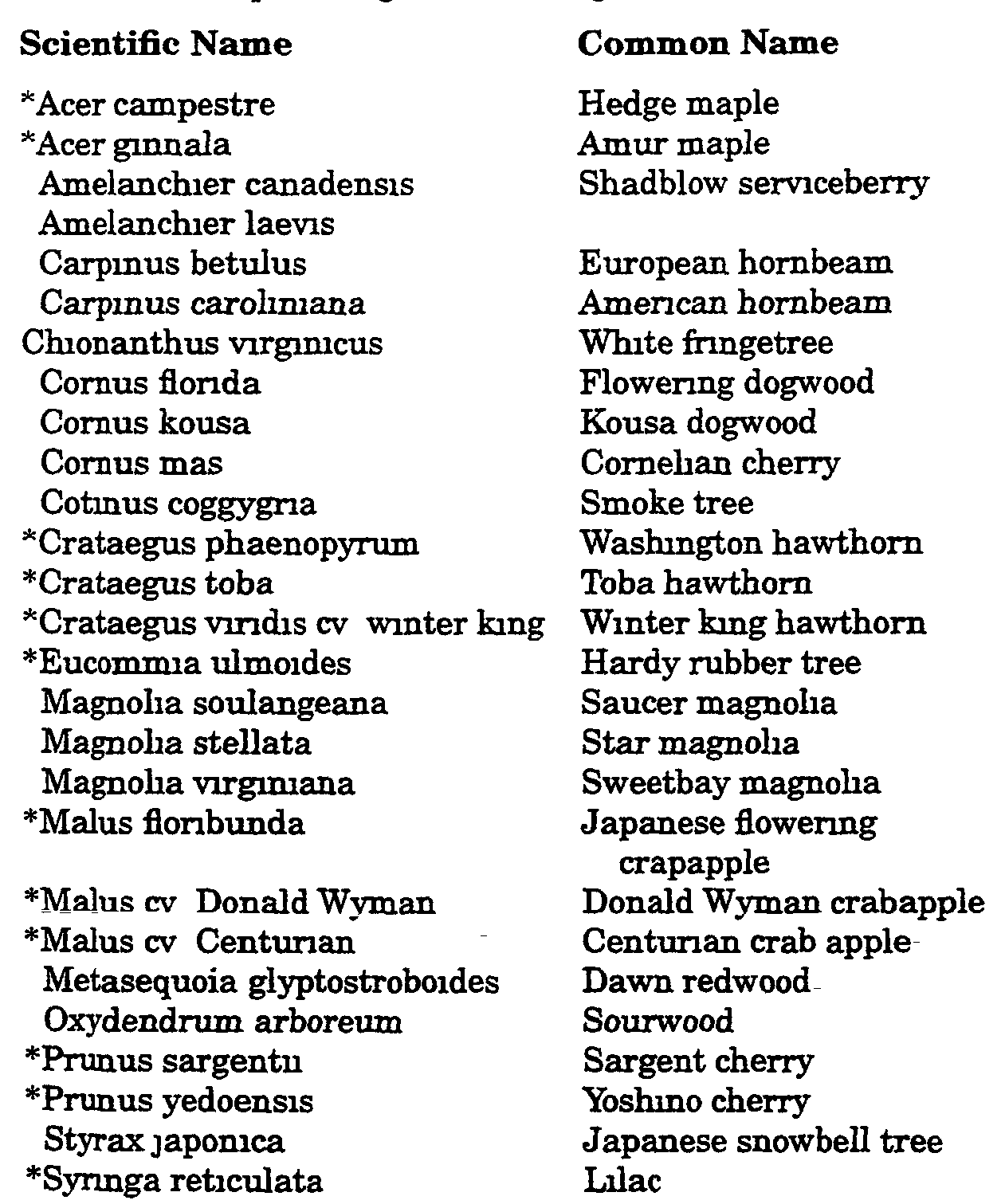
H. Recommended plant materials The following are recommended plant materials which are provided as guidance to the landowner or applicant Subsection H(1) and (2) includes those tree species considered to be well adapted to southeastern Pennsylvania and Worcester Township All trees listed may be used in rear and side yard buffers. Trees marked with an asterisk (*) have characteristics making them suitable for use as street trees or in buffers along streets Subsection H(5) provides a list of native trees and shrubs Indigenous to the region, they are hardy and well-adapted to the climate and soils All are commercially available, some as several varieties The use of native plant materials is encouraged to promote the preservation of native landscape diversity This approach maintains the natural character unique to this region and protects the associated wildlife habitat. These native materials are especially suitable in buffer plantings The township will permit other planting types than those specified on the following lists if the species are hardy to the area, are not subject to blight or disease and are of the same general character and growth habit as those listed below or subject to the approval of the Township Engineer or other designated professional�
(1) Canopy trees; minimum three-and-one-half-inch caliper�
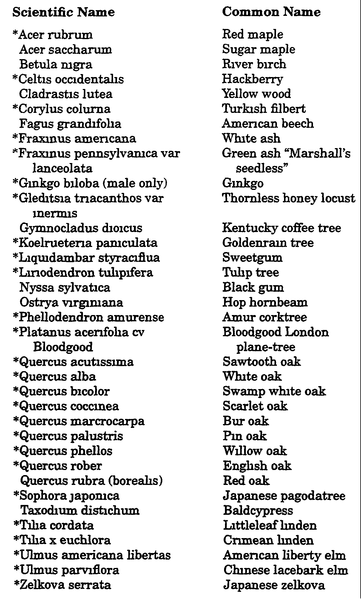
(2) Small understory trees minimum 2 1/2 inches in caliper or eight feet in height�