
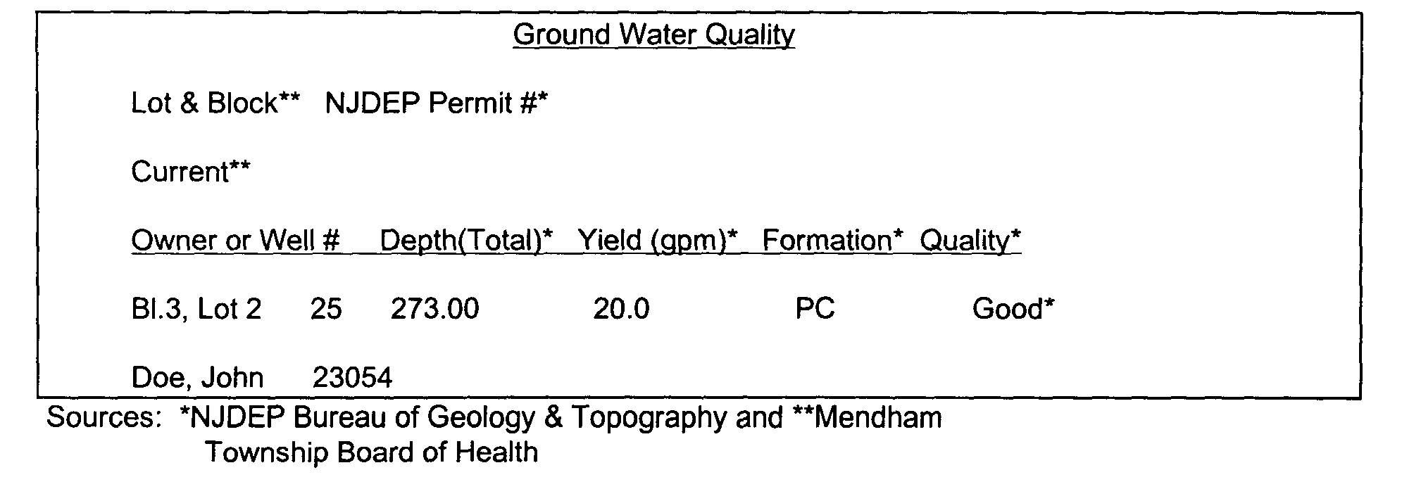
8. Ground water quality and supply shall be established with a search of Board of Health well records for all wells within 500' of the property. This data shall be presented in a tabular form and the location of the wells identified on a map of the area. Whenever a recorded adjoining well has a record of contamination, ground water quality on the site to be developed will be verified by installing a supply well. The supply shall be analyzed by a NJDEP Certified Laboratory for the compound(s) that resulted in the contamination of the nearby well and in addition pH, Nitrates, Phosphates, Chlorides, Fecal Coliform, Arsenic, Cadmium, Chromium, Copper, iron, Lead, Zinc and Mercury. In addition, any failed septic system within 1000' of the property shall be mapped and the cause of the septic system failure listed. In addition to descriptive text a figure presenting water supply and quality information shall be included in the format and example illustrated as follows:�
9. The quality of surface water bodies found within 1000' of the property which are tributary to the site or receive flow from the site shall be described with reference to the standards promulgated by the NJDEP in NJAC 7:9-4 et seq. When required, the description will include an analysis by a NJDEP Certified Laboratory that contains levels of the following constituents: temperature, pH, dissolved oxygen, Nitrates, Phosphates, Chlorides, Fecal Coliform, Arsenic, Cadmium, Chromium, Copper, Iron, Lead, Zinc and Mercury. These constituents shall be Compared to appropriate NJDEP standards as described in the Statutes of the State of New Jersey.�
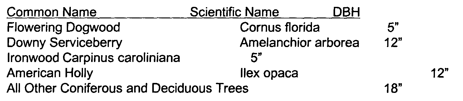
10. An inventory of flora and fauna observed or typically associated with the ecological conditions of the property shall be presented. The inventory shall include a listing of rare, threatened or endangered species identified by NJDEP's Office of Natural Heritage as having been inventoried on the property or within the vicinity of the property. The flora inventory shall include a description of all vegetation communities (including wetlands) or associations observed on the property, a map depicting the extent of those communities or associations and a description of the methodology used to develop the inventory. All specimen trees which have a drip line that is located within an area of clearing, excavation or grading shall be inventoried in the EIS and located and identified on the Environmental Constraints Map. For the purposes of this provision a specimen tree is one that exceeds the breast height diameter (DBH) specified on the following chart.�
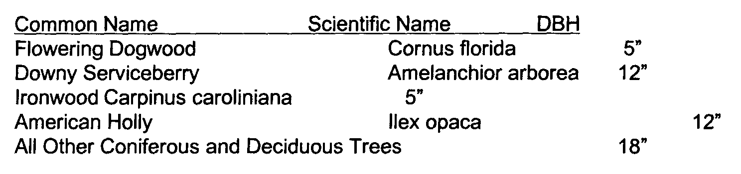
11. An inventory of avian, terrestrial and aquatic flora and fauna species shall be presented along with the environmental requirements for the species survival. The flora inventory shall include a description of the methodology used, inventory locations (including a map), a description and mapping of the extent of all vegetation communities and known occurrences of unique communities, rare or imperiled plant species and critical breeding or feeding habitat for rare, threatened or endangered fauna as recorded by NJDEP Natural Heritage program or on-site analysis. The fauna inventory will include observed species, method of observation, other species probable to occur on the site, known occurrences of threatened, endangered or rare species both on-site and within the immediate vicinity of the site. All specimen trees which have a drip line that is located within an area of clearing, excavation or grading shall be inventoried in the EIS; and located and identified on the Natural Resources Map. For the purposes of this provision a specimen tree is one that exceeds the breast height diameter (DBH) specified on the following chart.�
12. Wetlands as regulated by NJDEP at NJAC 7:7A-1, et seq., Freshwater Wetlands Protection Act Rules and floodplains as regulated by NJDEP at NJAC 7:13-1, et seq., Flood Hazard Control Act Rules.�
13. Light levels will be described in foot-candies at the property line adjacent to any Residential Zone.�
14. Ambient Sound levels will be described in Decibels on the A weighted scale (dB(A)'s) at the property line in accordance with the methods described at NJAC 7:29 B-1, et seq. The description will include time of day during which the observation was made, length of the observation, type of equipment used (with accuracy and date of most recent calibration), sound energy level influences observed and a comparison to the noise standard stated in NJAC 7:29 B-1, et seq.�
15. Known historic and archaeological sites occurring on the property or within 0.25 miles of the property will be listed along with the source of the information. Sources of information will include the Mendham Township Historic Preservation Committee, the Morris County Historical Society and NJDEP Historic Preservation Office. A survey of the property will be included depicting the location of all artifacts or structures indicative of prior development or habitation and other areas of archaeological interest.�
16. Community facilities that will support the proposed project including police, fire and emergency services and public schools (residential development proposals).�
b. Plan and Description of Development. The applicant shall provide a narrative description specifying the purpose of the project or changes of use; changes that will occur to the site from the proposed construction or use of the buildings and structures involved; and a comparison of the proposed changes to the zoning requirements of the Township. The narrative shall describe what is to be done and how it is to be done during the construction and operation of the project. The description shall include a schedule of construction and quantitatively enumerate the facts of the construction and operating systems of the proposal before the Planning Board or Zoning Board of Adjustment. This shall include but not be limited to land clearing, roadways/circulation/access, traffic generation, septage disposal, potable water supply, storm water management, solid waste disposal, hazardous waste disposal and public utilities. Inclusion of a map is unacceptable as a substitute for an adequate narrative description.�
The description shall be illustrated by maps and drawings contained within the environmental impact study which shall include, but shall not be limited to, contours, buildings, roads, paved areas, grading and regrading, adjacent natural streams, stream encroachment boundaries, the relation of the project to surrounding property and existing utilities and buffer zones for sound and light control. Maps and drawings illustrating features of the plan may be reduced and/or modified copies of the preliminary subdivision plat or site plan. However, they must be legible and clear.�
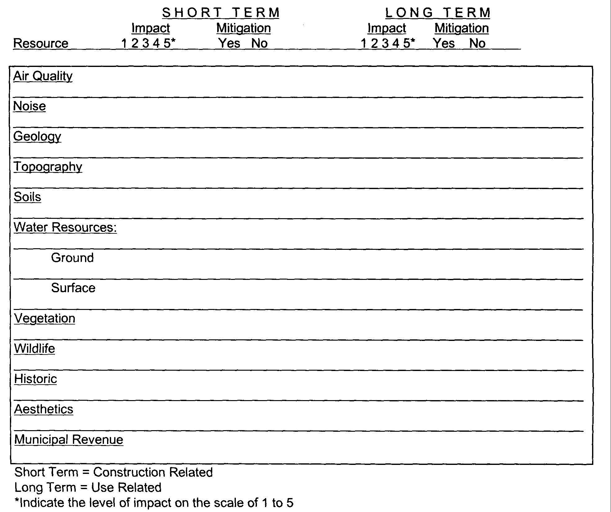
c. Assessment of the Anticipated Impact of the Project. The applicant shall provide an assessment, supported by quantitative data, of the probable beneficial or adverse impact of the project upon all of the elements and topics set forth in paragraph a. of this Subsection 17-3.1. The assessment shall include a summary listing of short term and long term impacts in accordance with the chart following this section. This assessment shall contain a written description and quantitative evaluation of adverse primary and secondary environmental impacts which cannot be avoided and mitigating measures being employed to avoid, reduce or eliminate such adverse impacts as may be anticipated. The assessment will place particular emphasis upon air or water pollution, increase in sound, damage to vegetation and wildlife systems, alteration of geologic features, soil disturbance, increase in the amount of sedimentation and siltation, increase in storm water runoff velocity and amount, increase in peak flow, displacement of people and businesses, displacement of existing farms, increase in the amount of sedimentation and siltation, storm water runoff, increase in municipal services and consequences to municipal tax structure.�
Environmental Impact Summary Chart�
The assessment shall specifically contain the following reports:�
1. Sewage Disposal Facilities. The report shall contain information demonstrating that sewage can be disposed of through facilities to preclude air and water pollution, and�
(a) if disposal is on-site, data on underlying geology, soil analysis, soil stratigraphy, topography, water table, percolation tests for every sewage disposal site, location and depth of aquifers and capacity, type of construction of all wells within 500 feet of the site, and other pertinent data; or�
(b) if disposal is off-site, a plan for disposal with a detailed description of expected quantity and classification of sewage effluent and acceptance approval in writing by the receiving facility; and�
(c) compliance with all state and local sewage and health regulations.�
2. Solid Waste Disposal. A plan for disposal by means of a facility operating in compliance with the State Sanitary Code, NJAC 7:9A-1/1, et seq., including suitable temporary on-site storage.�
3. Hazardous Waste Disposal (Where Applicable). Identification of and satisfactory provisions for disposal of hazardous materials as defined (by the State of New Jersey) at NJAC 7:26 et seq.. Proof of compliance with all applicable regulations must be provided.�
4. Water Supply and Water Quality. Evidence that an adequate potable water supply is available and the ratio of total anticipated demand to available supply, with source, shall be indicated. By reference to any study of water quality in the Township, the degradation of water quality shall be analyzed and reported.�
5. Surface Water Runoff. A calculation of the anticipated impacts to surface waters of the Township and plan to:�
a. Comply with municipal ordinances (Drainage).�
b. Prevent all point source and non-point source pollutants from entering the waters of the Township to the maximum extent practicable.�
c. Prevent degradation of surface water quality from the criteria established by NJDEP for Category 1, FW-1 and FW-2 Trout Production Waters.�
6. Air Quality. A calculation and statement of anticipated effects on air quality due to on-site activities such as: heating, incineration, any processing of materials and traffic. Compliance with Federal and New Jersey standards is required.�
7. Traffic (Pedestrian and Vehicular). An inventory of existing traffic and a calculation and statement of the projected effect of anticipated traffic on [all] proposed or existing roads directly affected within the Township.�
8. Sound. A statement of anticipated effects on ambient sound levels, magnitude and characteristics related to on-site activities and proposed methods of control.�
9. Artificial Light. A statement of the anticipated effects on light levels, magnitude and characteristics related to on-site activities and proposed methods of control with particular attention to the control of sky glow.�
10. Fire Protection. An assessment of the means to provide necessary fire protection for the proposed development. This shall include an analysis of the provisions for availability, source, quantity, storage, accessibility and delivery systems and methods of water for fire fighting purposes in accordance with Chapter XVI, Section 16-10.2(w) of the Mendham Township Land Use Ordinance.�
11. Fiscal Impact and Demography. A description of the impact to the tax base of the municipality, fiscal impact to the municipal and local school district fiscal outlook, utilization of local schools, impact to manpower and facilities requirements of police, fire and emergency services. The report shall include a computation of the fiscal impact to both the municipality and the local school system based upon the methods developed by the Center for Urban Planning at Rutgers University.�
12. Statement of Impact on Resources. A statement concerning any irreversible or irretrievable commitment of resources and unmitigated impacts which would be involved in the proposed project should it be implemented; the expected benefit derived to the Township shall be included.�
d. Statement of Alternatives. A statement of alternatives shall include a description of steps to be taken to achieve minimal environmental damage during construction and operation both at the project site and in the surrounding regions. Alternatives analysis shall be accompanied by necessary maps, schedules and other explanatory data as may be needed to clarify and explain the action to be taken and the rationale for using it. Alternatives analysis for changes of use will include a planning analysis of alternative uses for the site prepared by a New Jersey licensed professional planner.�
e. Statement of Permits Required. All municipal, county, state and federal permits required for the project shall be listed, together with a statement of the status of the applicant's efforts to comply with all such requirements and a project timetable for completion of compliance with all permit requirements.�
f. Environmental Constraints Map. The Environmental Impact Study as well as the Plan Set of an application for development shall include an Environmental Constraints Map or Maps, as needed for clarity, showing the following minimum information required for the assessment of impact:�
1. Topography at a contour of 2 feet (10 feet for slopes in excess of 25%).�
2. State Open Waters, Wetlands and Wetland Transition Areas.�
3. Flood Hazard Areas.�
4. Areas of glacial sediment deposits or calcareous bedrock geology.�
5. Soils information as specified in Section 17-3.1(a)4, herein.�
6. Rock outcrops and depth to bedrock.�
7. Depth to Seasonal High Water Table.�
8. Forested areas.�
9. Vegetation Communities mapped and predominant vegetation species for each community identified.�
The above information shall be superimposed by the proposed lot lines and/or development layout plan at a scale of not greater than 1" = 100'. The absence of any natural feature enumerated above shall be so noted on the map.�
For those applications requiring Planning Board or Zoning Board of Adjustment review, an original and thirteen (13) copies of the environmental impact study, including all maps and plans and other supporting documents and a reverse line sepia for any map or drawing submitted by the applicant shall be filed with the Planning Board or Zoning Board of Adjustment.�
For those applications requiring only Township engineer review, an original and six (6) copies of the environmental impact study, including all maps and plans and other supporting documents, shall be filed with the Township clerk, who shall distribute: two (2) copies to the Township engineer, one (1) copy to the construction official, one (1) copy to the Planning Board or Zoning Board of Adjustment, and one (1) copy to the Environmental Commission for information.�
Each applicant shall pay a filing fee to the Township clerk based on the schedule set forth in Chapter XIII, Subsection 13-14.1.g.�
The Planning Board or Zoning Board of Adjustment shall have a period of 60 days after the filing of a complete environmental impact study to review the study and act thereon, provided that whenever land subdivision or site plan approval is applied for the Planning Board or Zoning Board of Adjustment shall complete its review and action on the environmental impact study within the same period of time within which the Planning Board or Zoning Board of Adjustment is required to act upon the application for subdivision or site plan approval. The time within which the Planning Board or Zoning Board of Adjustment may act may be extended with the consent of the applicant.�
In reviewing an environmental impact study, the Planning Board or Zoning Board of Adjustment shall take into consideration the effect of the applicant's proposal upon all aspects of the environment including, but not limited to, water quality, water supply, protection of water courses, protection of aquifers, sewage disposal, soil erosion, protection of trees and vegetation, protection of farm land and open space, protection of air, protection of wildlife and wildlife habitats, protection of aesthetics, historical sites and archeological features and the minimization of any nuisances or harmful effects upon ambient sound and light levels and characteristics. The Planning Board or Zoning Board of Adjustment shall submit the environmental impact study for review and comment to the environmental commission and to such other governmental bodies as it may deem appropriate. The Planning Board or Zoning Board of Adjustment shall take into consideration the effect of the applicant's proposed project upon all aspects of the environment as outlined above as well as the sufficiency of the applicant's proposals for dealing with any immediate or projected primary or secondary adverse environmental effects. In particular, the Planning Board or Zoning Board of Adjustment must be satisfied that point and non-point pollution of streams and ground water can be avoided and storm water runoff from the site is controlled in compliance with the provisions of the New Jersey Flood Hazard Control Act (NJAC 7:13, et seq.). Additionally, the Planning Board or Zoning Board of Adjustment must conclude that the applicant's project will not result in undue adverse impacts to the local or regional environment. The Planning Board or Zoning Board of Adjustment shall not approve any submission under this chapter unless it determines and finds that the proposed development�
a. will not result in undue adverse impacts to the environment,�
b. has been designed and conceived with a view toward the protection of regional resources, and�
c. will not place a disproportionate or excessive demand upon the total resources available for such proposal or for any future proposals.�
�
The steps to be taken to minimize adverse environmental impacts during construction and operation which may be approved by the Planning Board or Zoning Board of Adjustment shall constitute conditions of the approval of the environmental study, together with such other conditions as the Planning Board or Zoning Board of Adjustment may impose. Ail work may be stopped by the Township Engineer if specified construction restraints are not followed. No certificate of occupancy shall be issued until compliance shall have been made with all conditions.�
The Township Engineer shall have a period of 30 days after the filing of a complete environmental impact study filed pursuant to Subsection 17-2.2 to review the study and act thereon. The time within which the Township Engineer may act may be extended with the consent of the applicant.�
In reviewing an environmental impact study, the Township Engineer shall take into consideration the effect of the applicant's proposed project upon all aspects of the environment as outlined above as well as the sufficiency of the applicant's proposal for dealing with any immediate or projected primary or secondary adverse environmental effects. In particular, they must be satisfied that point and non-point pollution of streams and ground water can be avoided and storm water runoff from the site is controlled in compliance with the provisions of the New Jersey Flood Hazard Control Act (NJAC 7:13, et seq.). Additionally, the Township Engineer must conclude that the applicant's project will not result in undue adverse impacts to the local or regional environment. The Township Engineer shall not approve any submission under this ordinance unless they determine and find that the proposed development:�
a. will not result in undue adverse impacts to the environment,�
b. has been designed and conceived with a view toward the protection of regional resources, and�
c. will not place a disproportionate or excessive demand upon the total resources available for such proposal or for any future proposals.�
The steps to be taken to minimize adverse environmental impacts during construction and operation which may be approved by the Township Engineer shall constitute conditions of the approval of the environmental impact study, together with such other conditions as the Township Engineer may impose. All work may be stopped by the Township Engineer if specified construction restraints are not followed.�
�
An environmental impact study approved by the Township Engineer shall accompany each application for a construction permit for a building or structure to which the provisions of this ordinance apply and no such construction permit shall be issued in the absence thereof. An application for a certificate of occupancy following the completion of any such construction shall be accompanied by a certificate issued by the Township Engineer stating that there has been compliance with the approved study and all conditions thereof, and no certificate of occupancy shall be issued in the absence of such certification. Upon the request of an applicant, the Township Engineer shall furnish to the applicant a written statement of action to be taken by the applicant to effect compliance.�
Any person aggrieved by any decision of action of [the Township in the administration of the provisions of this chapter may appeal to the Planning Board in writing, such appeal to be filed with the Township Clerk within thirty (30) days from the date of the decision or action of which there is a complaint. The appellant shall be entitled to a hearing before the Planning Board, which shall fix a date therefor not more than forty five (45) days from the date of the decision or action which is the subject of the appeal. Upon such hearing or within ten (10) days thereafter the] Planning Board shall affirm, alter or rescind the decision or action complained of by resolution setting forth written findings of fact and legal conclusions.�
a. There shall be no filing fee.�
b. If the appeal is not filed within thirty (30) days following the decision(s) or action(s) of the Township Engineer any decision(s) or action(s) made by him shall be deemed final.�
An environmental impact study as required by this chapter shall also be submitted as to all public or quasi-public projects unless they are exempt from the requirements of local law by supervening county, state or federal laws, provided, however, that the provisions of this chapter shall not apply to road and road shoulder maintenance work performed by the Township department of public works.�
Every environmental impact study required by this chapter shall be prepared by a licensed professional engineer in the State of New Jersey or such person as shall satisfy the Planning Board or Zoning Board of Adjustment or the Township Engineer, as the case may be, that he/she possesses expertise in the environmental field by virtue of training, experience or education.�
�
The Planning Board or Zoning Board of Adjustment may waive the requirement for an environmental impact study, in whole or in part, if sufficient evidence is submitted to support a conclusion that the proposed project will have a negligible environmental impact or that a complete environmental impact study need not be prepared in order to evaluate adequately the environmental impact of a project.�
Where approval of the environmental impact study is within the authority of the Township engineer he may waive the requirement for an environmental impact study, in whole or in part, if sufficient evidence is submitted to support a conclusion that the proposed project will have a negligible environmental impact or that a complete environmental impact study need not be prepared in order to evaluate adequately the environmental impact of a project.�
Any person who shall within the Township make any change in the use of any land or building, or remove any trees or other vegetation in an area of more than 1,000 square feet, or disturb earth by power driven equipment in an area more than 1,000 square feet without first having received approval of an environmental impact study in accordance with the provisions of this chapter shall be guilty of a violation of this chapter and shall be subject to the penalty set forth in Chapter VI, Section 6-7 of the Revised General Ordinances of the Township of Mendham, 1970; provided, however, that the foregoing shall not apply to any person engaged in an activity which is exempt under Subsection 17-2.3 or Section 17-7 or in an activity as to which the Planning Board or Zoning Board of Adjustment has waived the requirement for an Environmental Impact Study.�
Any person who shall within the Township perform any work on any development or other project, with respect to which an environmental impact study has been approved in accordance with this ordinance, in a manner which is contrary to the provisions or conditions thereof designed to minimize adverse environmental impacts during construction and who shall not within five (5) days after receiving written notice from the Township Engineer of deviation from the aforesaid provisions and conditions undertaken to effect compliance with such provisions or conditions shall be guilty of a violation of this ordinance and shall be subject to the penalty set forth in Chapter VI, Section 6-7 of the Revised General Ordinances of the Township of Mendham, 1970.�

