In order that the Township of Mendham may assess the impact of proposed land use changes or developments on the environment of the municipality, particularly with respect to potable water, pollution of all kinds, drainage, waste disposal, landscape and other pertinent environmental factors, the Township Committee has determined that it is in the public interest that all persons who shall propose such changes or developments shall submit an environmental impact study (EIS) in accordance with the provisions of this chapter when required.�
An environmental impact study relative to the proposed project prepared in accordance with the provisions of this chapter shall be submitted for approval to the Planning Board or Zoning Board of Adjustment of the Township in the following instances:�
a. In connection with all applications for land subdivision;�
b. In connection with all applications for site plan approval;�
c. Prior to the change in the use of any land or building;�
d. Prior to the removal of trees or other vegetation in an area of more than 1,000 square feet; or�
e. Prior to the disturbance of earth by power driven equipment in an area of more than 1,000 square feet.�
An environmental impact study relative to the proposed project in accordance with the provisions of this ordinance shall be submitted to the Township Clerk for approval by the Township Engineer in connection with all applications for a construction permit or a certificate of occupancy.�
The following are exempt from the requirements of submitting an environmental impact study: agricultural uses conducted in accordance with a farm conservation plan approved by the state soil conservation service; single-family residential uses or structures accessory thereto in a residential zone whenever such residential uses or structures involve no more than 5,000 square feet of land disturbance; and minor subdivisions intended to re-align lot lines and which will not result in further development of any property involved..�
Every environmental impact study shall include the following:�
An Inventory of Existing Environmental Conditions�
Plan and Description of Development�
Assessment of the Anticipated Impact of the Project�
�
Statement of Alternatives t�
Statement of Impact on Resources �
Statement of Permits Required�
Environmental Constraints Map�
The level of detail that will be required in the environmental impact study will be determined by the size and intensity of the proposed project. The minimum requirements are set forth below:�
The topics discussed in the EIS as noted above shall determine the completeness of an application. Items omitted or not specifically identified may be included at the discretion of the Planning Board or Zoning Board of Adjustment.�
a. An Inventory of Existing Environmental Conditions, An inventory of existing environmental conditions at the project site and in the surrounding region which is affected by the project will be presented. The Inventory will be specific to the property under review. The contents of the inventory of each resource will include information as follows:�
1. A description of the property and its surrounding area up to a 0.5 mile radius shall be provided that includes the current use of the land proposed for development and that of the surrounding area.�
2. Air quality shall be described with reference to standards promulgated by the Department of Environmental Protection of the State of New Jersey at NJAC 7:27, et seq., and in accordance with the Mendham Township Natural Resources Inventory.�
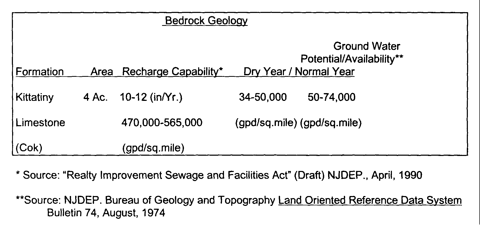
3. Surficial and Bedrock Geology will be described according to the most recent information prepared by the New Jersey State Geologist. In particular ground water recharge areas, aquifers and reported ground water availability will be included in tabular form and shown on a map of the site. An illustration of the tabular format with example information is given below.�