
In addition to the purpose and statement of community development objectives found in this chapter, the specific intent of this district shall be to protect areas of floodplain subject to and necessary for the containment of floodwaters and to permit and encourage the retention of open space land uses which will be so located and utilized as to constitute a harmonious and appropriate aspect of the continuing physical development of Worcester Township Furthermore, in light of the township's certification as eligible for Federal Flood Insurance, it is the intent of thus district to provide adequate protection for floodprone properties within Worcester Township In advancing these principles and the general purpose of the Zoning Ordinance and Comprehensive Plan, the following shall be the specific objectives of the Floodplain Conservation District�
A. To combine with the zoning requirements certain restrictions made necessary for flood-prone areas to promote the general health, welfare and safety of the township�
B. To prevent the erection of structures in areas unfit for human usage by reason of danger from flooding, unsanitary conditions or other hazards�
C. To minimize danger to public health by protecting the quality and quantity of surface and subsurface water supplies adjacent to and underlying flood hazard areas and promoting safe and sanitary drainage�
D. To permit only those uses which can be appropriately located in the floodplain, as herein defined, and which will not impede the flow or storage of floodwaters or otherwise cause danger to life and property at, above or below their locations along the floodplain�
E. To protect those individuals who might choose, despite the flood dangers, to develop or occupy land on a floodplain�
F. To protect adjacent landowners and those both upstream and downstream from damages resulting from development within a floodplain and the consequent obstruction or increase in flow of floodwaters�
G. To protect the entire township from individual uses of land which may have the effect upon subsequent expenditures for public works and disaster relief and adversely affect the economic well-being of the township�
H. To maintain undisturbed the ecological balance between those natural system, elements, including wildlife, vegetation and marine life, dependent upon watercourses and water areas�
I. To protect other municipalities within the same watershed from the impact of improper development and the consequent increased potential for flooding�
J. To provide areas for the deposition of flood-borne sediment�
K. To require that uses vulnerable to floods be developed so as to be protected from flood damage in accordance with the requirements of the Federal Flood Insurance Program�
L. To prevent excessive development in areas unsatisfactory therefore by reason of flooding, and related hazards�
M. To provide retention areas for the temporary storage of floodwaters�
N. To provide sufficient drainage courses to carry abnormal flows of stormwaters in periods of heavy precipitation�
A. The Floodplain District is defined and established as those areas of the township subject to flooding as defined in Subsection A(1), (2) and (3) listed below�
(1) [Amended 12-18-1996 by Ord. No. 155] Those areas subject to inundation by the waters of the one-hundred-year flood as delineated in the Flood Insurance Study (FIS) and the Flood Insurance Rate Map (FIRM) for the Township of Worcester, Montgomery County, Pennsylvania, as prepared by the Federal Emergency Management Agency TEMA), Federal Insurance Administration (FIA), dated December 19, 1996, or the most recent revision thereof Said floodplain shall be comprised of three subdistricts as follows�
(a) FW (Floodway Area) the areas identified as "Floodway" in the AE Zone in the Flood Insurance Study prepared by the FEMA The term shall also include floodway areas which have been identified in other available studies or sources of information for those floodplain areas where no floodway has been identified in the Flood Insurance Study.�
(b) FF (Flood-Fringe Area) the remaining portions of the one-hundred-year floodplain in those areas identified as an AE Zone in the Flood Insurance Study, where a floodway has been delineated The basis for the outermost boundary of this area shall be the one hundred-year-flood elevations as shown in the flood profiles contained in the Flood Insurance Study�
(c) FA (General Floodplain Area)�
[1] The areas identified as-Zone A in the FIS for which no one-hundred-year-flood elevations have been provided When available, information from other federal, state and other acceptable sources shall be used to determine the one-hundred-year elevation, as well as a floodway area, if possible When no other information is available, the one-hundred-year elevation shall be determined by using a point on the boundary of the identified floodplain area which is nearest the construction site in question�
[2] In lieu of the above, the township may require the applicant to determine the elevation with hydrologic and hydraulic engineering techniques Hydrologic and hydraulic analyses shall be undertaken only by professional engineers or others of demonstrated qualifications, who shall certify that the technical methods used correctly reflect currently accepted technical concepts Studies, analyses, computations, etc, shall be submitted in sufficient detail to allow a thorough technical review by the township�
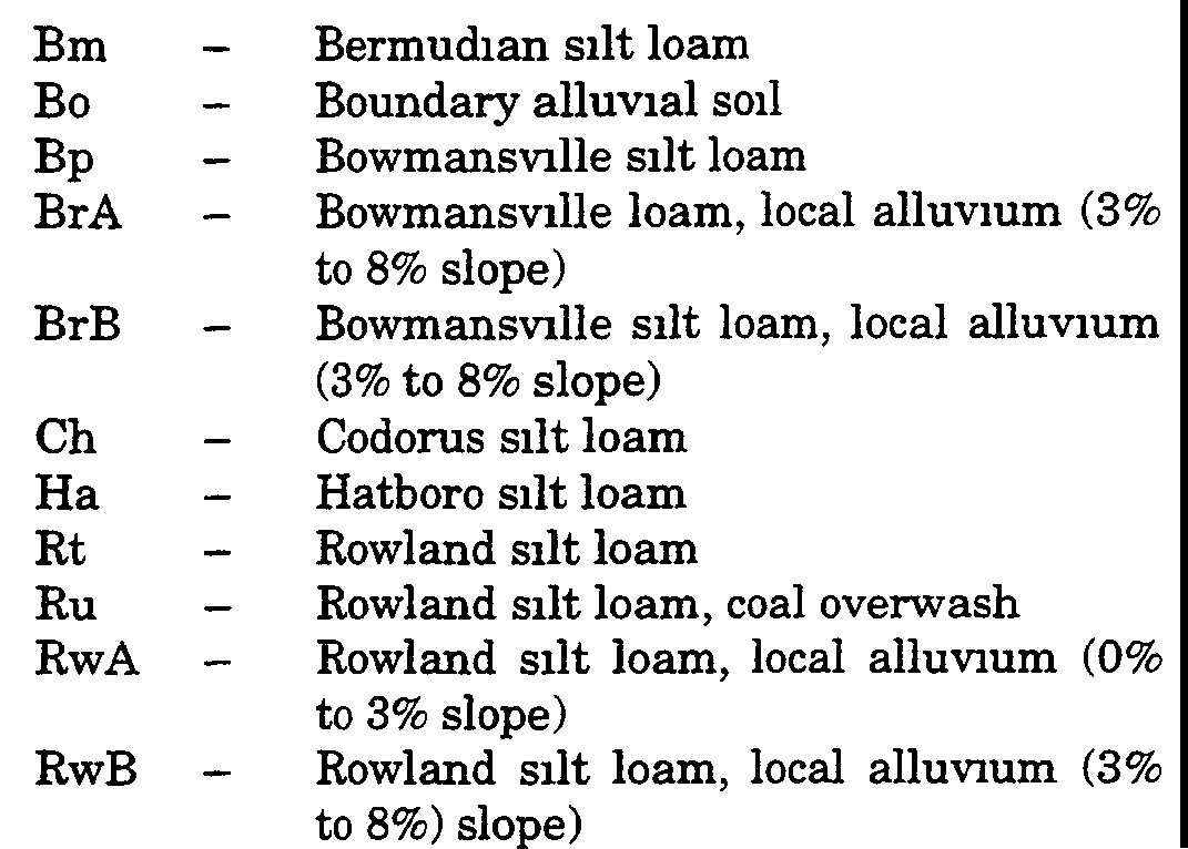
(2) The low area adjoining and including any water or drainagecourse or body of water subject to periodic flooding or overflow and delineated as alluvial soils or local alluvium by the Soil Conservation Service, United States Department of Agriculture, in the Soil Survey of Montgomery County, 1967, may be considered as part of the Floodplain Conservation District, any party wishing to develop in such area shall supply engineering studies to the township sufficient so that the Township Engineer may determine if said area(s) are to be considered as a floodplain If said area(s) is not part of the area proposed for building, the township may not require such studies at the advice of the Township Engineer, but the township shall require said soil areas to be appropriately identified on all subdivision, development or building plans to be submitted to the township �
Alluvial Soils�
�
(3) Areas which are not reflected in Subsection A(1) or (2) above but which have been subject to inundation during a one-hundred-year frequency flood These areas shall be identified by field survey, as well as hydrologic and hydraulic calculation, and shall be subject to the review of the Township Engineer�
B. The Floodplain District shall be delineated on the Flood Insurance Rate Map (FIRM) which is hereby made a part of this chapter and is available for inspection at the township offices [Amended 12-18-1996 by Ord. No. 155]�
C. Any change in the Floodplain District as from time to time may be determined to be proper hereunder shall be forthwith reflected on said map�
D. Studies used to establish the floodplain boundaries shall be available in the township offices for reference�
The Floodplain District shall be deemed an overlay on any zoning district now or hereafter applicable to any lot�
A. Should the Floodplain District be declared inapplicable to any tract by reason of action of the Township Supervisors in amending this chapter or the Zoning Hearing Board or any court of competent jurisdiction in interpreting the same, the zoning applicable to such lot shall be deemed to be the district in which it is located without consideration of this district�
B. Should the zoning of any parcel or any part thereof in which the Floodplain District is located be changed through any legislative or administrative actions or judicial discretion, such change shall have no effect on the Floodplain District unless such change was included as part of the original application�
C. Except where this Article prescribes a greater setback due to the boundaries of the floodplain as defined in § 150-136 herein, the minimum setback from any watercourse for a structure shall be equal to the horizontal distance from the top of the bank of the watercourse extended to a point at which the elevation is one foot above the elevation of the top of the bank, as verified by the Township Engineer All changes to the boundaries of the Floodplain Conservation District are subject to review and approval of the Federal Insurance Administrator�
�
A. The following uses and no other shall be permitted in a Floodplain District�
(1) Cultivation and harvesting of crops in accordance with recognized soil conservation practices�
(2) Pasture and grazing land in accordance with recognized soil conservation practices�
(3) Outdoor plant nursery or orchard in accordance with recognized soil conservation practices�
(4) Wildlife sanctuary, woodland preserve, arboretum and passive recreation or parks, including hiking, bicycle and bridle trails, but including no facilities subject to damage by flooding�
(5) Forestry, lumbering and reforestation in accordance with recognized natural resource conservation practices, but permitting no structures�
(6) Utility transmission lines with the approval of applicable state agencies and the Supervisors�
(7) Front, side or rear yards and required lot area for any district�
(8) Public roadways, private roadways and driveways where no other realistic design or alignment is possible and only with the approval of applicable state agencies and the Supervisors [Amended 4-17-1996 by Ord. No. 146]�
B. All permitted uses are subject to the Floodproofing Regulations and the office of the Chief Engineer, United States Army Any of the uses or development activity in Subsection A above shall not be permitted within the floodway unless the effect of such proposed activity on flood -heights- is fully offset -by accompanying stream improvements The floodproofing measures referred to in this subsection are applicable only for nonresidential structures since the residential structures must be elevated to or above the base flood elevation Floodproofing measures for all nonresidential structures shall satisfy the requirements of the completely dry spaces (WI) and essentially dry spaces (W2) classes referenced in the above regulations The specific elevation and/or floodproofing requirements are set forth in § 150-143E herein [Amended 12-18-1996 by Ord. No: 155]�
The following uses shall not be permitted in the Floodplain District�
A. All freestanding structures, buildings, mobile homes, manufactured housing and retaining walls and any grading or filling, including stormwater control facilities�
B. The relocation of any watercourse without approval of the Board of Supervisors, the relocation of any watercourse without a permit from the Pennsylvania Department of Environmental Resources Where an encroachment permit is required by the Pennsylvania Department of Environmental Resources, such permit application shall be forwarded to any affected adjacent municipalities, the Pennsylvania Department of Community Affairs and the Federal Insurance Administration 30 days prior to any hearing or formal Board action�
C. Sanitary landfills, dumps, junkyards, outdoor storage of vehicles and miscellaneous materials or storage of any buoyant, toxic or dangerous materials�
D. On-site sewage disposal systems�
E. Private water supply wells�
F. Paved or all-weather parking lots [Amended 4-14-1996 by Ord. No 146]�
G. No encroachment in the Floodway District that would cause any rise in the one-hundred-year base flood elevation [Amended 12-18-1996 by Ord. No. 155]�
H. Stripping of top soil groundcover, vegetation or removal of trees within 20 feet of a stream bank�
The following uses shall be banned in any floodplain area and no variance shall be granted�
A. Any new or substantially improved structure which will be used for the production or storage of any of the following dangerous materials or which will by used for any activity requiring the maintenance of a supply (more than five gallons or other comparable volume or any amount of radioactive substances) of any of the following dangerous materials or substances on the premises�
(1) Acetone�
(2) Ammonia (3) Benzene�
(4) Calcium carbide �
(5) Carbon disulfide �
(6) Celluloid �
(7) Chlorine �
(8) Hydrochloric acid �
(9) Hydrocyanic acid �
(10) Magnesium�
(11) Nitric acid and oxides of nitrogen�
(12) Petroleum products (gasoline, fuel oil, etc) �
(13) Phosphorus�
(14) Potassium�
(15) Sodium�
(16) Sulphur and sulphur products�
(17) Pesticides (including insecticides, fungicides and rodenticides)�
(18) Radioactive substances�
B. The construction, enlargement or expansion of any structure used or intended- to be used for any of the following�
(1) Hospital�
(2) Nursing home�
(3) Jail or prison�
C. The commencement of or any construction of a new mobile home park or mobile home subdivision or substantial improvement to any existing mobile home park or mobile home subdivision�
A. [Amended 12-18-1996 by Ord. No. 155] A zoning permit shall be required before any construction or development is undertaken within any Floodway District An application for a zoning permit shall be filed with the Zoning Officer who shall make an initial determination on the proposal�
(1) Prior to the issuance of any zoning permit, the Zoning Officer shall review the application for permit to determine if all other necessary governmental permits such as those required by state and federal laws have been obtained, including those required by Act 537, the Pennsylvania Sewage Facilities Act, the Water Obstruction Act of 1913, and the Federal Water Pollution Control Act amendments of 1972, Section 404, 33 U S C § 1334 No permit shall be issued until this determination has been made�
(2) For uses other than those permitted in § 150-138 of this chapter, an application seeking approval of a variance shall be forwarded to the Zoning Hearing Board along with the required studies or information and the findings of the Zoning Officer�
(3) If the proposed development is to be located within the Floodway District, the application shall include a certification from a registered engineer that the development will not cause any increase in the one-hundred-year-flood levels within the community or that any such increase will be fully offset by accompanying watercourse improvements�
B. The application for variance shall be accompanied by the following�
(1) Detailed engineering studies indicating the effects of the proposed use on drainage and streams on all adjacent properties as well as the property in question�
(2) Supporting documents of studies as required by the Township Engineer�
All applications for approval of variances shall be considered using standards listed in § 150-143�
A. The Zoning Hearing Board shall request the review and recommendations of the Pennsylvania Department of Environmental Resources and the Montgomery County Conservation District at least 30 days prior to the public hearing�
B. The Zoning Hearing Board shall request, at least 30 days prior to a public hearing, the review and recommendation of the Worcester Township Planning-Commission and the Township Engineer�
C. In rendering a decision, the Zoning Hearing Board may impose special measures or conditions as deemed necessary and appropriate for the use to conform with the intent of this chapter�
The Zoning Hearing Board shall exercise discretion in allowing only those uses which are substantially in- accordance with the stated objectives in § 150-135 herein The Zoning Hearing Board, in considering variance applications, shall consider the following�
A. The effect of the use shall not substantially alter the cross-section profile of the stream and floodplain at the location of the proposed use�
B. Lands abutting the waterway, both upstream and downstream, shall not be adversely affected by the proposed use�
C. The general welfare or public interest of Worcester Township or of other municipalities in the same watershed shall not be adversely affected�
D. Any new structures permitted by a variance shall be constructed and placed on the lot so as to offer the minimum obstruction to the flow of water and shall be designed to have a minimum affect upon the flow and height of floodwater [Amended 12-18-1996 by Ord. No. 1551�
E. Any structure permitted by variance shall include floodproofing measures according to the following criteria�
(1) Elevation [Amended 12-18-1996 by Ord. No. 155]�
(a) A residential structure shall have the lowest floor, including basement, elevated up to or above the one-hundred-year-flood elevations,�
(b) A nonresidential structure shall have the lowest floor, including basement, elevated up to or above the one-hundred-year-flood elevation or be designed and constructed so that the space enclosed by such structure shall remain either completely or essentially dry during any flood up to that height as described in § 150-138B�
(c) All plans and specifications for completely or essentially dry floodproofing shall be accompanied by a statement, certified by a registered professional engineer or architect, which states that the proposed design and methods of construction are in conformance with such standards�
(2) All such structures shall be firmly anchored to prevent flotation, collapse or lateral movement as evidenced by the design and report of a registered structural or civil engineer�
(3) All such structures shall be constructed so as to prevent the entrance of floodwaters into the water supply and waste treatment systems as well as other utility and facility systems In addition, waste treatment systems shall be designed to minimize or eliminate discharges from the systems into the floodwaters�
(4) apace below the lowest floor [Added 12-996 by Ord. No. 155]�
(a) Fully enclosed space below the lowest floor (including basement) is prohibited�
(b) Partially enclosed space below the lowest floor (including basement) which will be used solely for the parking of a vehicle, building access or incidental storage in an area other than a basement shall be designed and constructed to allow -for the automatic entry arid exit of floodwaters for the purpose of equalizing hydrostatic forces on exterior walls The term "partially enclosed space" also includes crawl spaces Designs for meeting this requirement must either be certified by a registered professional engineer or architect or meet or exceed the following minimum criteria�
[1] A minimum of two openings having a net total area of not less than one square inch for every square foot of enclosed space�
[2] The bottom of all openings shall be no higher than one foot above grade�
[3] Openings may be equipped with screens, louvers, etc , or other coverings or devices, provided that they permit the automatic entry and exit of floodwaters�
F. Unsubstantial improvements, substantial improvements [Amended 12-18-1996 by Ord. No. 1551�
(1) Any additions or improvements to existing structures permitted by variance and which are not substantial improvements shall be elevated to the greatest extent possible according to the provisions in Subsection E and applicable current federal and state regulations However, any portion of the structure not so elevated shall be floodproofed in accordance with Floodproofing Regulations, United States Army EP 1165 2 314 and consistent with the requirements of §150-143E(1) of the Code of the Township of Worcester�
(2) Any modification, alternation, reconstruction or improvement of any kind to an existing structure, to an extent or amount of 50% or more of its market value, shall constitute a substantial improvement and shall be undertaken only in full compliance with the provisions of § 150-143E of thus article�
G. An affirmative decision shall not be issued by the Zoning Hearing Board within the designated floodway if any increase in the flood level during the base flood would result�
H. The Zoning Hearing Board shall notify the applicant, in writing over the signatures of the Board, that the issuance of a decision to allow construction of a structure below the base flood elevation will result in increased premium rates for flood insurance and such construction below the base flood elevations increases risks to life and property Such notification shall be maintained with a record of all decisions as required in this section�
I. The Zoning Hearing Board shall maintain a record of all variances, including the conditions and justification for issuing (also included shall be, where applicable, and where required pursuant to § 150-143E herein, the elevation of the lowest floor and the elevation to which floodproofing measures were carried for structures allowed by variance), and report the number of variances requested and granted in annual report to the Federal Insurance Administration [Amended 12-18-1996 by Ord. No. 155]�
J. Requests for variances shall be considered by the Zoning Hearing Board in accordance with the following�
(1) Affirmative decisions shall only be issued by the Zoning Hearing Board upon showing of good and sufficient cause, a determination that failure to grant the appeal would result in exceptional hardship to the applicant and a determination that the granting of an appeal would not result in increased flood heights, additional threats to public safety or extraordinary public expense or create nuisances, cause fraud on or victimization of the public or conflict with existing local laws or ordinances�
(2) Affirmative decisions shall only be issued upon determination that it is the minimum necessary, considering the flood hazard, to provide relief�

