The Steep Slope Conservation District has been designed to promote public health, safety and welfare of the Township residents through limiting environmental disturbance on land with natural steep slopes. The district is intended to protect and conserve hillsides from excessive development which could cause conserve hillsides from excessive development which could cause accelerated erosion and increased runoff, resulting in increased flood hazards downstream. The district attempts to protect natural vegetation so as to maintain a high quality of water in the various streams flowing through the Township. (Amended 7/5/89)(Amended 6/10/91)
The Steep Slope Conservation District consists of slopes greater than twelve percent. In any application for subdivision, land development and/or building permits where the tract includes areas of Steep Slopes, the applicant shall, using two (2) foot contours, delineate slopes greater than 12%. Further the applicant shall use an actual field topographic survey or aerial survey as the source of contour information and the basis for depicting Steep Slopes. (Amended 1.27.97)
The Steep Slope Conservation District is further divided and defined as follows:
A. Low Intensity Slope District.
This district includes all lands-with slope measuring between twelve and twenty percent (12 and 20%).
1. If the net lot area is less than one acre or major construction is proposed to extend beyond forty (40) feet within the Low Intensity Slope, then for the purposes of establishing lot size, the entire lot shall be considered to be in the Low Intensity District and shall require a gross area as prescribed by Section 1205.A.3 of this Ordinance.
2. This section shall apply only to those slopes between twelve and twenty percent which exist for three (3) or more consecutive two (2) foot intervals and which are greater than 1,000 square feet in area. Isolated areas of land between twelve and twenty percent or that are not continuous over three contour intervals, must be shown on the plan, but are not subject to the restrictions of this section. Land slopes between twelve and twenty percent may not be averaged with areas of less than twelve percent for the purpose of reducing the area of Low Intensity Steep slopes. Small areas of less than twelve percent slope occurring in the midst of larger areas of Low Intensity Slope ground shall be considered part of the Low Intensity Steep Slope District.
B. Conservation Slope District.
This district includes all lands with slopes greater than twenty percent (20%).
1. If the net lot area is less than one acre, or the net lot area plus the Low Intensity Slope District is less than two and one half acres, or major construction is proposed to extend beyond twenty (20) feet within the Conservation Slope, then for the purposes of establishing lot size, the entire lot shall be considered to be in the Conservation Slope District and shall require a gross area as prescribed by Section 1205.B.4 of this Ordinance.
2. This section shall apply only to those slopes over twenty percent which exist for three (3) or more consecutive two (2) foot intervals and which are greater than 1,000 square feet in area. Isolated areas of land over twenty percent, or that are not continuous over three contour intervals, must be shown on the plan, but are not subject to the restrictions of this section. Land slopes over twenty percent may not be averaged with areas of less than twenty percent for the purpose of reducing the area of Conservation Steep Slopes. Small areas of less than twenty percent slope occurring in the midst of larger areas of Conservation Slope ground shall be considered part of the Conservation Slope District.
C. Major construction
Major construction includes, but is not limited to, construction of building, driveways, sewage disposal systems, outbuildings and grading.
The Steep Slope Conservation District, based on the delineations cited in Section 1202, shall be deemed an overlay to the otherwise applicable zoning district, as defined by the London Britain Township Zoning Map. Should the Steep Slope Conservation District be determined as inapplicable to any tract by reason of amendment by the Board of Supervisors, or a court of competent jurisdiction, the underlying zoning provisions shall be deemed applicable and shall be enforced independent of this Article.
To assist in the interpretation of steep slope conservation district boundaries, any application for subdivision or land development shall delineate slopes from twelve to twenty percent (I 2 to 20%) and slopes greater than twenty percent (20%) with different shading. The contour interval shall be two (2) feet. (Amended 5/9/94)
Initial interpretations shall be made by the Township Engineer. Appeals shall be made to the Board of Supervisors. The burden of proof shall be on the party filing for the hearing.
A. Low Intensity Slope District
1. Uses By Right
a. Tree farming, forestry and other agricultural uses, provided such activities do not involve tilling or clearcutting operations, and that such uses conform with conservation practices which prevent soil erosion and increased storm water runoff than occurred prior to the use.
b. Arboretum, woodland preserve, or conservation and recreation uses.
c. Single-family dwelling.
d. Private yard area.
2. Permitted Accessory Uses
a. Customary accessory agricultural uses and buildings.
b. Customary accessory residential uses and building.
c. Parking areas to serve recreational areas using permeable paving.
d. Stormwater management facilities.
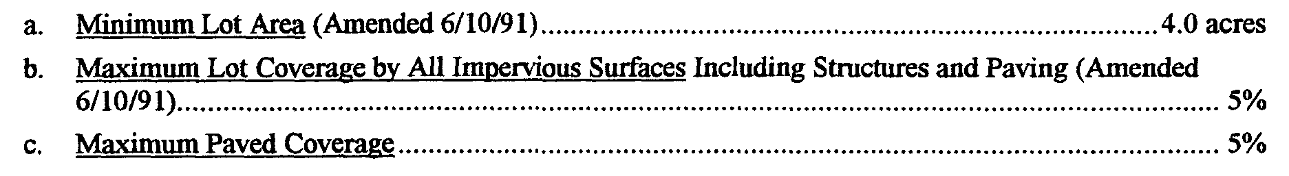
3. Area and Bulk Requirements
The provisions of the underlying district shall govern area and bulk requirements except for the following regulations:
B. Conservation Slope District
1. Uses By Right
a. Tree farming, forestry and other agricultural uses, provided such activities do not involve tilling or clear-cutting operations, and that such uses conform with conservation practices which prevent soil erosion and increased storm water runoff than occurred prior to the use.
b. Arboretum, woodland preserve, or recreational use, provided the proposed use presents no conflict with the continued function of the land as a watershed.
c. Yard areas of residences, provided all buildings and structures comply with Section 812 of this Ordinance. (Amended 6/10/9 1)
2. Conditional Uses:
a. Agricultural structures and cultivation.
b. Conservation and recreation uses requiring structures.
c. Utility easements and rights-of-way.
d. Single-family dwelling.
e. Enlargement or alteration to an existing dwelling.
3. Criteria For Conditional Uses.
In addition to the provisions established in Article XI for conditional uses, the following criteria shall be considered by the Planning Commission and the Board of Supervisors for applications which involve a Conservation Slope District:
a. The applicant shall demonstrate to the satisfaction of the Board of Supervisors that the proposed use shall not substantially alter the existing grade (as shown by cross-sections through areas to be disturbed) not remove more than five percent (5%) of the existing vegetation. (Amended 6/10/91)
b. The applicant shall demonstrate in writing how emergency vehicles can reach the site. (Amended 6/10/91)
c. To assist the Board in it's evaluation, the applicant shall submit additional information including, but not limited to:
i. site plan showing: (Amended 6/10/91)
(a) the location of sewage and disposal and water supply.
(b) the amount and location of cut and fill and the temporary and/or permanent disposition of excavated soil. (Amended 6/10/91)
(c) existing grades with contour lines at two (2) foot intervals, including proposed final grades. (Amended 6/10/91)
(d) a cross-section of the property indicating the location of buildings, structures, and grading operations, including proposed, final grades. (Amended 6/10/9 1)
(e) a landscaping plan which identifies all trees within twenty (20) feet of all proposed grading and construction which have a diameter exceeding eight (8) inches, measured three (3) feet about the ground and locates trees and shrubs to be removed and replaced. (Amended 6/10/91)
(f) the location and method(s) used to revegetate any disturbed areas and explanations of why these methods were chosen over alternatives. (Amended 6/10/91)
(g) the disposition of cut trees and other vegetative debris. (Amended 6/10/91)
(h) architectural plans, where applicable, including materials and type of foundation to be used to overcome structural problems associated with the slope conditions. (Amended 6/10/91)
(i) the location and concept design or storm water management systems. (Amended6/10/91)
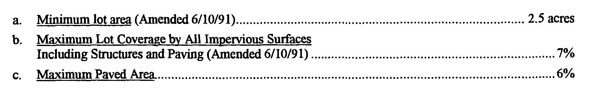
4. Area and Bulk Regulations.
The provisions of the underlying district shall govern Area and Bulk requirements, except for the following regulations: